A planned chase in west Texas gets called off, but lightning and a shelf cloud with a nocturnal MCS make the trip worth it.
This was a true on-a-whim chase attempt that I didn't expect much out of, but came away from fairly satisfied. It had been a week and a half since the last chase day (Feb 28, total bust), and models were showing a very unfavorable pattern setting up for the next week to 10 days, so we figured doing something crazy for a chance to see some storms wasn't too unreasonable, being that it was a Saturday night. A decent setup was anticipated over parts of west Texas on Sunday afternoon as an upper-level low closed off over E NM, but unfortunately, the best instability was quite a ways south in the San Angelo to Del Rio corridor. After much squabbling and second-guessing each others' seriousness about actually going anywhere, Brandon convinced Trey and I to join him and head out around 3:00am Sunday morning, with the intention of stopping for some rest in Wichita Falls and re-assessing the situation after sunrise.
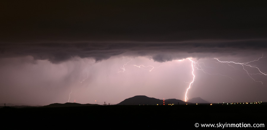
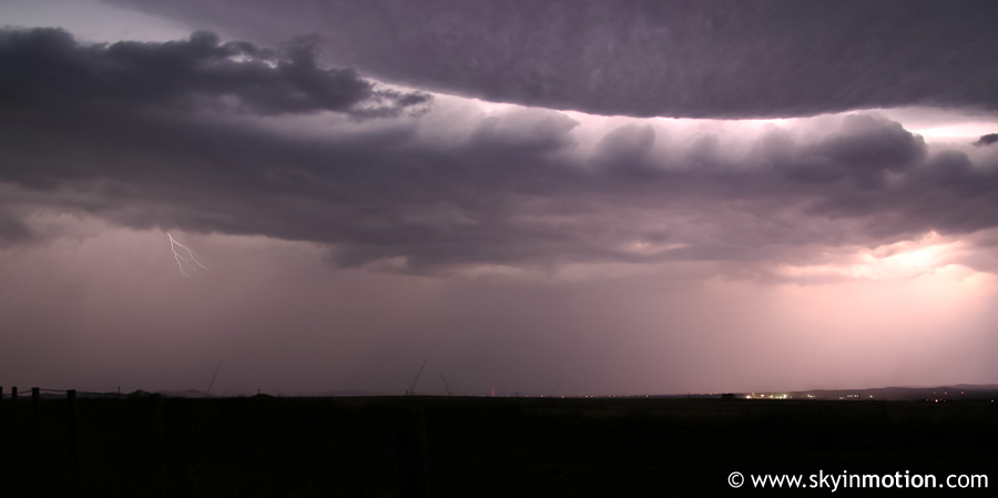
Suffice it to say, the best part of the "chase" unfolded much earlier than we expected. Only 15 minutes into our drive down I-44, we got a call that the leading edge of an MCS in W OK/NW TX had taken on a bow appearance on radar, and reports of 65-80 mph winds were coming in from the Altus-Frederick-Quanah area. Not long afterwards, we began to see frequent lightning on the southwestern horizon; after enjoying the show from the car for awhile, we decided to stop along I-44 about 15 miles short of Lawton for some photography and video. We watched in awe for a good 20 minutes as frequent CG and CC strikes drew closer and closer, illuminating a very impressive-looking shelf cloud. This provided some of the best storm photo opportunities I'd had since September, though forgetting to switch from JPEG to RAW format on my camera did hurt the quality a little. All these photos below were shot between 4:30 and 5:00 AM from northeast of the Wichita Mountains.
After the outflow winds reached our location and lightning became too close for comfort, we scurried back to Brandon's car and observed modest gusts and some small hail, along with torrential rain that continued for the remainder of the drive to Wichita Falls. We arrived at our "intermediate destination" between 5:30 and 6:00 AM, and immediately pulled into a motel parking lot for wifi. The new data did not look too compelling - a big mess of "crapvection" was still ongoing across west-central Texas and appeared to be moving directly into the target area, promising to inhibit daytime heating. For the next couple hours we layed low waiting for the new SPC day 1 outlook and additional model data, but all indications were that even the Abilene to San Angelo corridor - an additional 3 or more hours from Wichita Falls at highway speeds - might be too far north for good supercells. Sure enough, the new outlook shifted the risk area even farther south and out of reach unless we were willing to commit to a downright insane amount of driving for a mediocre setup. We turned around a little after 8:00, not in the best spirits, and made it back to Norman by 10:45am. The lightning show definitely saved the outing from being a complete waste, though.