An incredibly well-timed (a.k.a., lucky) intercept of an HP supercell near Waco gives us a brief tornado less than a mile away.
Observed 1 tornado.

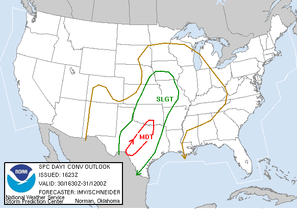
This was a day I was very hesitant about even committing the time to chasing, but was certainly glad I did in the end. It can be hard to get motivated on those days with a warm front well to the south, meaning a dull, dreary drive down to the target area; such was the case this day. Initially, it appeared the primary threat area for significant severe and tornadoes was southern West Texas, from Del Rio to Abilene. Since it was a Friday, we were already giving serious thought to flying down to that area after our 9:00 AM meteorology classes despite the distance, though we began to question whether it was worth it and stall upon returning to look at the latest data. However, by late morning, the warm front was observed to be making notable northward progress, prompting a northward extension of the moderate risk area into the Red River Valley on the 1630 UTC outlook.
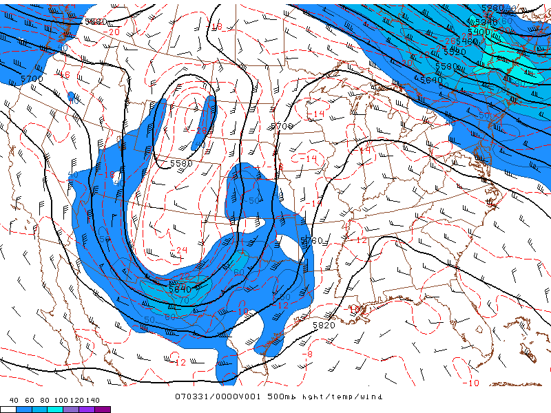
Wind shear was impressive to say the least, but instability was questionable thanks to lots of clouds near and north of the warm front. Brandon, Bryan, Trey and I departed around 1:00 in Brandon's car, planning to stop in Ardmore to view data and determine whether to wait it out there or head into TX. When we arrived (after a miserable cold, rainy drive down I-35), the situation was almost laughable for areas north of I-20; a huge mass of stratiform rain with embedded convection had developed from NW TX into a large portion of OK, which would clearly squash any possibility of decent instability, and would also serve to keep the warm front from making much more northward progress. We quickly decided to press south.
There was some disagreement in the car on how to circumnavigate the congestion of DFW, since we were now targetting I-20 between Fort Worth and Abilene. Trey and I wanted to take the long, scenic route out to Decatur and then south to I-20 at Weatherford in order to avoid the metroplex traffic, while Bryan and Brandon were convinced that I-35W would be our best bet since it wasn't quite rush hour yet (it was now around 3:30). We ended up going with the latter, thank goodness, because as we approached Fort Worth, we got a call from Aaron letting us know that there was a fairly discrete, tornado-warned supercell well to our south between Lampasas and Gatesville, and little else chase-worthy in the vicinity. So now we abandoned our plan of heading west on I-20 in favor of getting farther south as quickly as possible.
The gridlock while approaching and passing downtown Fort Worth was nerve-wracking, to say the least. After being stuck for 20 minutes or so, I began to lose all hope for the day and was secretly hoping we'd just turn around as soon as we got out of the mess. Eventually, by the time we crossed into Johnson County, the traffic thinned out quite a bit, allowing us to resume highway speeds. While we still had about 75 miles to go before reaching Waco, Aaron informed us via cell that the storm, which was still tornado-warned, was moving northeast (almost paralleling I-35W) rather than east, and was not flying or anything despite the fairly strong mid-level flow. We raced down to Waco as quickly as possible, still under stratus and occasional rain despite having made it south of the surface boundary, arriving a little after 5:00. By that time, the latest tornado warning was indicating a track through or just south of Waco as the storm continued northeastward; while we'd normally be overjoyed at positioning ourselves right in the path (especially after being almost certain we'd be too late while we were stuck!), the situation started to worry me as rain increased in intensity rapidly, reducing visibility to near zero. To make matters worse, the signs in Waco were poorly marked and my GPS was giving me trouble, so we took some wrong turns, eventually getting it right by taking TX-6 southeast out of town. While we were frantically trying to find that road option, we were under simply torrential rain in the core of the storm, and noted significant flooding, particularly when crossing the Brazos River, which was nearly up to the bridge.
Approaching Riesel, we suddenly exited the torrent of rain and gained a view of the ominous base of the storm directly ahead to the south and southeast. It was fairly tough for us to identify features of the storm in our relative inexperience, since it appeared to be HP. Nevertheless, we stopped at a gas station in Riesel as the base closed in on us, exhibiting rotation in various areas, which kept us on our toes. After a few minutes, it seemed that the clearest rotation was occurring very closeby to our southwest and was approaching rapidly, so we hurried southeastward another half mile or so to get out of its direct path.
After stopping in a construction area on the road (there wasn't enough traffic for this to be a real problem), our confusion continued, until Bryan suddenly pointed out a very thin funnel about a mile to our northwest. Though it's very hard to make out in the photos and not even obvious enough in-person to grab one's attention unless they were looking for it, it was definitely there. A couple seconds later, we observed debris on the ground just west of the highway about a mile to our north in Riesel, though the condensation funnel still did not meet with the ground.
There was a close call with a vehicle driving southbound on the highway just as the small debris cloud was about to cross, but fortunately, the tornado lifted before reaching it. The duration of this first touchdown was at most 15 or 20 seconds. The funnel cloud stayed intact and moved northeast across the highway, though, briefly appearing to touch down again on the north side of town before performing an awesome rapid/wild rope-out, which can be seen well on Brandon's HD video (hopefully it will be posted online sometime).
While we were watching the small twister, rain had begun again, and was picking up by the time the tornado had lifted for a second time. Our choices were either to head back northwest on TX-6 to get on TX-1860 northeastbound after a couple miles, or to drop well south for the next northeast option, keeping us out of the core. I was strongly for doing the latter, considering heading any farther north would put us right back in the same flooded mess we'd (barely) made it through in Waco; plus, if the tornado reformed, we might easily come right out of the core and into the tornado by heading northeast. With much reservation, we quickly headed southeast to meet up with TX-7 at Marlin, then blasted east to Kosse for a much-needed gas refill. Afer that, we spent the next hour or so trucking northeast on TX-14 through Limestone and Freestone counties trying to catch back up with our storm, but by the time we did, it was quite apparent it had weakened and become disorganized. After some fun driving around on backroads, where we eventually encountered major flooding in the form of a river crossing the road in front of us, we hopped on I-45 south of Coriscana and began the journey home.
Even with the long drive and brevity of the tornado, this was a unique day I really appreciated, as we were the only chasers (to our knowledge) on the storm, and were able to intercept a tornado in a rather "unconventional" area that few chasers even bother with. I'm about as dismissive of chasing in poor terrain as anyone, but central TX was not all that bad - definitely more tree coverage than would be ideal, but it was still quite flat and the trees were fairly short. It certainly beat chasing in most of OK east of I-35.