The yin-yang of storm chasing: one of my worst busts via screw-ups follows a banner day.
Incompetent decision-making, traffic, poor road options, and the list goes on: this day was so bad I never stood a chance. Sometimes, when you blow a big day, it stings extra bad because you keep deluding yourself all day that you might be able to catch the latter part of the show, even after many of your contemporaries have seen five stovepipes. In this case, I more or less knew my fate before the "chase" was even 1/3 over, though. Suffice to say, had I not scored one of the best storms of my life the previous evening, it would have been hard finding the motivation even to finish the drive home.
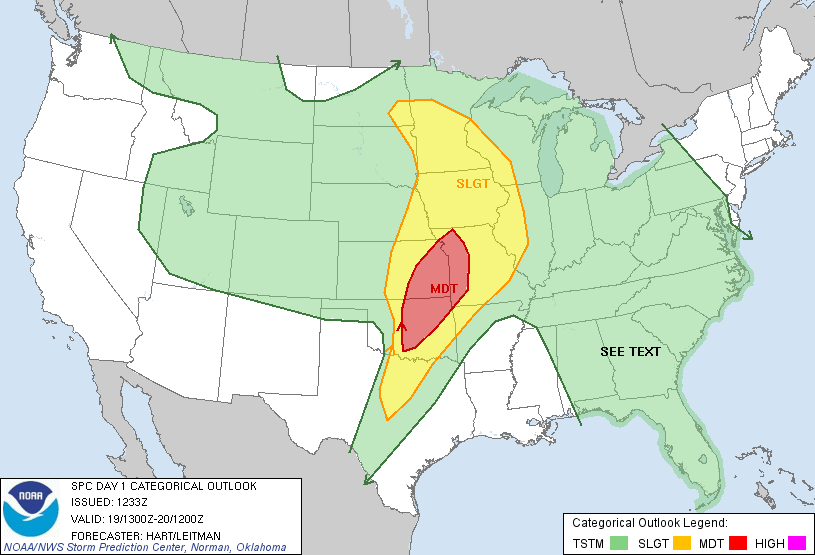
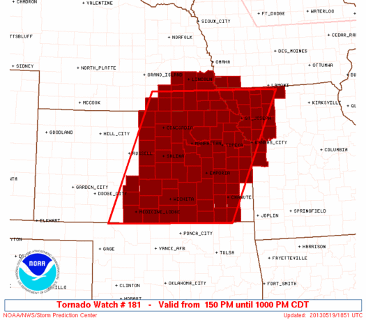
The target for the day eerily resembled 2010-05-10: essentially, along the I-35 corridor from just S of OKC up to around ICT, and extending E from there toward the AR and MO borders. I knew I would likely repeat my errors of that horrific day, and even told several people so beforehand. At least I forecasted something about the day correctly. Although I had every intention of targeting S KS from the time I woke up, I was more sluggish than usual in leaving due to fatigue and the potential for action closer to home. Even so, I managed to leave just barely early enough to seal my fate -- something I've done countless other days in which I knew the metro featured high potential. I blasted up I-35 to Blackwell, where I planned to wait, but was drawn N by explosive development at the dryline-cold front intersection near ICT. While the initial storm produced a large tornado over the SW suburbs, I was too late and it was rain-wrapped anyway.
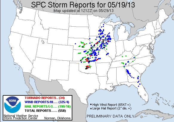
My compulsive tendency to hedge every decision as long as possible really did me in. I meandered NE to Rose Hill, where I believed I could choose between jumping to the ICT storm after it cleared urban areas and busting S for new triple point cells. I was so reluctant to commit quickly to the latter that I missed the brief, but somewhat photogenic, tubes near South Haven. Worse yet, I saw visions of what would unfold later in the evening down S the first time I viewed KTLX reflectivity, while the incipient Edmond-Carney storm was still near Yukon. Alas, I'd boxed myself in. I started S down US-77, but had to contend with the major slow-down that is PNC. Had the cap not been a factor so quickly with eastward extent, I might still have joined the wedgefest, albeit in horrendous terrain around TUL. Instead, a comedy of errors ensued in which I arrived on both the Edmond-Carney and Lake Thunderbird-Shawnee supercells 1-1.5 hours after their most prolific tornado production, right as dramatically increased CINH in E OK was taking its toll. There's little point recounting the details of my unpleasant foray into the jungles, which appropriately concluded with my driving haplessly into the core of the Shawnee storm as it passed S of Bristow, losing all visual of storm features. I reluctantly retreated back N into town, where I had trouble even finding fast food joints still open at 8:30pm (oh, Sunday in the Plains). I at least made it home before midnight, tracing a route along I-44 I hope not to again on a chase day for years to come.