
The fail was strong with this one: a mad dash Deep in the Heart of Texas leaves me with lots of annoyances and no good storms.
There are bad chase days that don't unfold exactly as you'd like, and then there's a whole separate tier where absolutely nothing can go right, down to the smallest details. That was April 13 for me. The season had been dismal thus far, and thanks to a poorly-timed wave, the only chase opportunity for 7-10 days either side of this wasn't looking very promising, either. Still, some hope was apparent along the dryline in north TX, provided convection could develop following morning grunge and crapvection.
Most model guidance for 48 h leading up to this event showed low probabilities for sustained convection S of the Red River, where the environment appeared most favorable for surface-based supercells and tornadoes. In OK, a cold front was forecast to crash across the length of the state in a matter of 6-10 hours, beginning during the early afternoon. While you can never completely rule out a tornadic supercell along cold fronts, they're few and far between, and rarely look very pretty when they do occur.
By 1pm, though, visible satellite was showing vigorous Cu all along the dryline from around SPS to ABI and southward. I blasted S on I-35 and quickly saw that convection was indeed developing in that region, despite so little model support. Great; initiation was the main concern, and now it was basically eliminated! It's rarely so simple, though. Seriously, it amazes me to think back on so many busted chases where I identified one or two primary issues to watch as I left home, only for something entirely different to be the limiting factor in the end. Maybe that's part of chasing's allure in some sick, subconscious way.
I exited I-35 at Gainesville and took TX state highways to Decatur, then WSW toward Mineral Wells, where the northernmost of three dryline storms was ongoing. This northern storm had been struggling since its inception over an hour earlier, so I wasn't shocked to see it completely die within half an hour of my arrival.
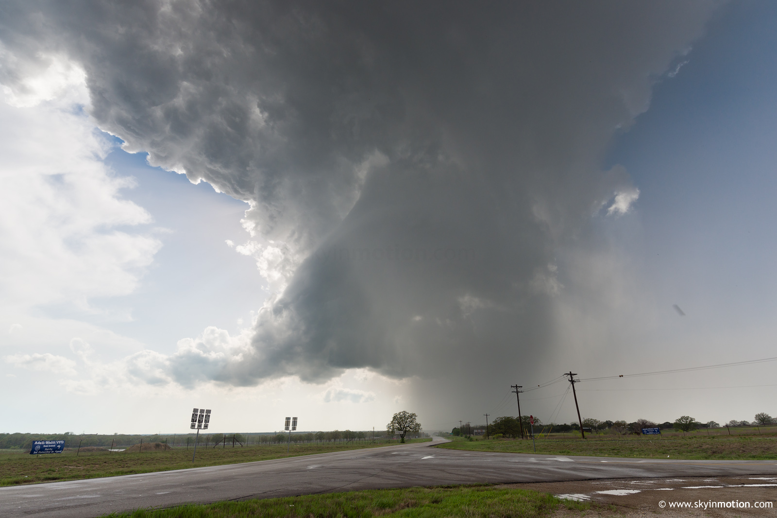
Unfortunately, despite a relatively impressive environment from a CAPE-shear perspective, the low-level stabilizing effects from morning convection and clouds were too prohibitive for sustained storms. Thankfully, another supercell was ongoing about 50 mi. SW of there, near Cisco. I again blasted S toward Stephenville, knowing I needed to close a lot of distance before the forward flank overtook my road options (this storm looked on radar like a stereotypical north TX ice machine, regularly pushing 70 dBZ).
I made great time between Millsap and Stephenville, thanks in large part to the glorious new 75 mph speed limits on many TX highways -- even two-lane sections! Stephenville itself was a different story; Sunday drivers abound, and this was the most crucial portion of my hail-evading mission, as the core was closing in rapidly to my SW. Just in the nick of time, I escaped the hell of clueless rural drivers and blasted SW on US-67 to Dublin, where I finally met up with the target storm. By now, around 6pm, this formidable supercell had been a deviant right-mover exhibiting impressive radar structure for at least two hours. As I came into town, I could make out a blocky wall cloud over the trees and buildings. Five minutes later, when I'd staked out a good viewing spot, the wall cloud was completely gone. Ten minutes after that, radar indicated a precipitous drop in updraft intensity, and it was clear that CINH would rapidly kill this storm like it had the last one.
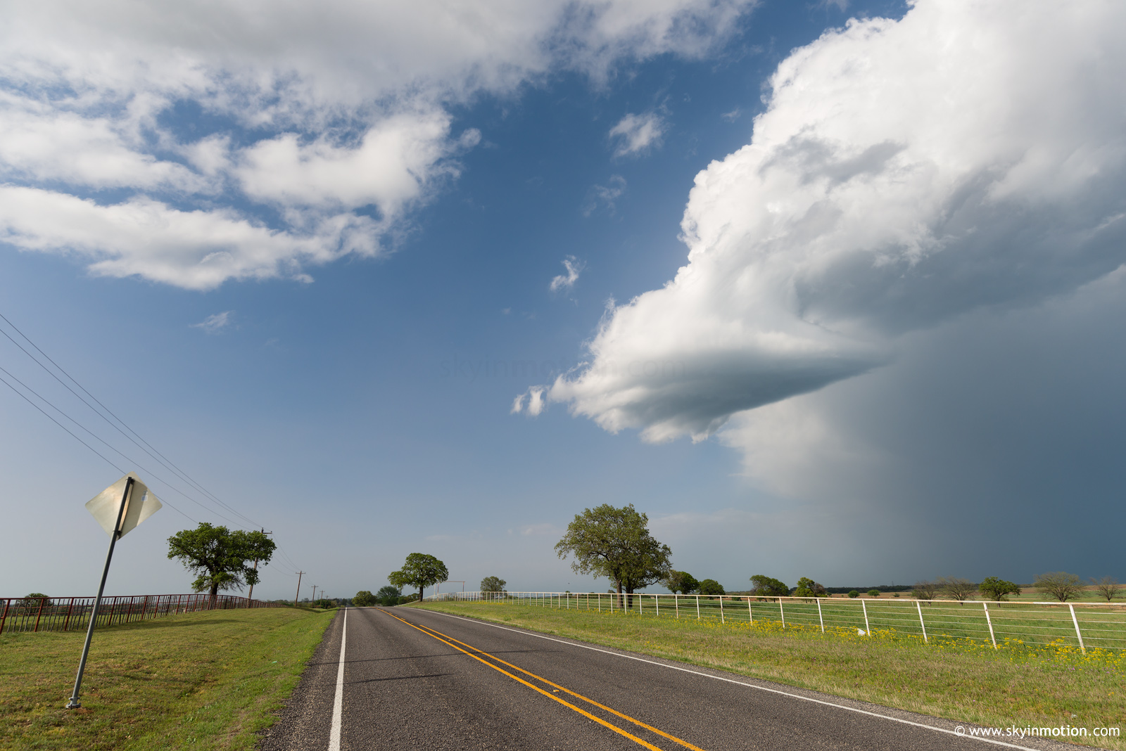
Even having driven 300 miles from OUN just to kill two separate supercells immediately with my arrival (one previously long-lived), I was not yet at my breaking point. I hadn't expected a lot from the day, and I still had hopes of doing some sort of storm photography with bluebonnets in the foreground. In preparation for the "skeleton LP updraft" phase of the dying Stephenville storm, I blasted S toward Purves to get a more complete view from behind. Along the way I encountered numerous patches of wildflowers, but none were situated properly for photography with the storm in the background. Eventually I conceded that idea and figured I ought at minimum to shoot the storm with what crappy foregrounds there were. As I did that, I noticed a very nice rainbow in the distance, barely visible beneath the storm from my vantage. Little did I know, the numerous chasers who'd simply sat around Dublin in defeat as the storm died were treated to a beautiful view of the double rainbow against deep blue skies, which made for cell phone pictures a hundredfold more worthy of printing than anything I got.
I wasted even more time meandering between Dublin and Clairette in a desperate attempt to salvage a sunset photo op, but obtained nothing worth the effort to process and post here. I finally made it back to Stephenville around 7:50pm, and found the local BBQ joint (one of the few appeals of north TX chasing) was closing in 10 minutes. Screw it, then; I'll just grab Whataburger quickly and be on my way! Well, that was the plan. Instead, it took over 20 minutes from the time I ordered to having the bag in hand, by which point I decided I'd just eat there after wasting so much time.
Now 8:45pm, I return to the car to find that the southernmost of the three original TX dryline supercells is still raging 40 mi. to my SE. To recap: of the three initial dryline storms, two were completely eviscerated by the cap as soon as I arrived during the late afternoon... while the final storm, the one I decided not to mess with given a clear pattern, continued unabated well into the night. In fact, it traversed an environment near the I-35/I-45 corridors that, from a mesoscale point of view, should have suffered similar capping effects (at least at some point in its eastward progression) to what my storms had. Awesome! My disgust at this fact was brief, as I soon had an even bigger source of regret: exceptional structure photos pouring in from a cold front supercell near Ardmore, which had also produced a brief tornado near Duncan.
In summary: I had driven way too far from home to see the best this day had to offer, and yet not quite far enough for the consolation prize in central TX. I had literally maximized the mileage driven for no reward that any rational chaser could have committed, even doing so on a small scale around Dublin by hauling S for "structure" and missing the rainbow.
I made the long drive from Stephenville to Ft. Worth in a rather miserable state, then starting catching distant glimpses of stout updrafts with frequent lightning way off to the E of Denton through the dry post-frontal air. Now 11:30pm, I decided to make one last-gasp effort to justify having even brought my camera bag by shooting lightning with my telephoto lens. I pulled off on a paved county road about 2 mi. E of I-35 somewhere around Valley View. Within a minute, an SUV comes by, which is more or less commonplace when you're spotted by rural Plains residents. Interestingly, it returned and made another pass a couple minutes later, slowing but not rolling down the window to say anything. Finally, it came back a third time and the middle-aged female driver started peppering me with questions: what was I doing on "her" road? Who was I? Oh, an OU student? -- show her my ID so she can be sure! I (somewhat) politely refused, saying I'd gladly leave if I was on her property, but reminding her that she'd already admitted I was on a public road. After a short argument, she proceeded to call the cops on her cell and give them my plate. I hurled my equipment into the car and left, seeing no point in shooting more headlight-tainted exposures, nor in waiting for Barney Fife's decision on whether to indulge this freedom-loving Texan's demands that anyone "not from 'round here" be strip-searched as a condition for being present on a road near her home. I made it to Norman around 1am. All I can say is that mid-late season 2014 better knock my socks off.


