Epic fail strikes again in 2014, as morning convection ruins an otherwise-explosive dryline setup.
An extremely impressive pattern was forecast several days in advance for Sunday, April 27, with a negative-tilt trough plowing through a seasonably moist warm sector. The zenith of the setup's appearance was about 48 hours prior, when computer guidance depicted a scenario fairly similar to historic Plains tornado outbreaks around this time of year (e.g., 26 Apr 1991). The one big fly in the ointment was troughing along the east coast, which the modeling struggled with badly. A week out, the troughing looked so severe as to completely squash the warm sector below I-20 and eliminate any substantial severe threat; two days out, it had waned to the point of allowing a major outbreak.
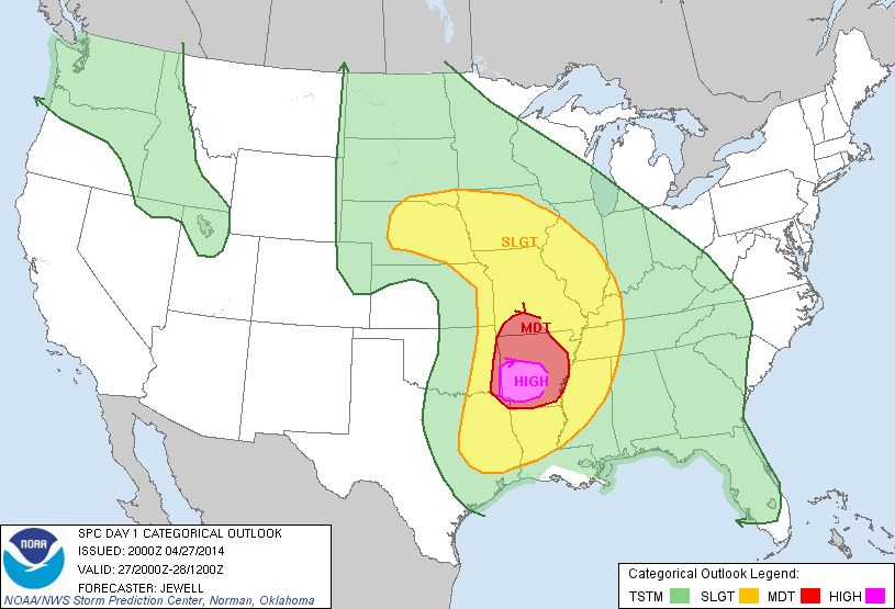
Ultimately, the troughing (and resultant upstream blocking ridge over the Midwest) was just strong enough to derail the potential for a major tornado event in the Plains on this day. While the warm sector was rich and extensive, the primary shortwave became "pinched" over the central High Plains by the downstream ridge, resulting in a closed upper low and a cyclone that was nearly vertically stacked on April 27. The dryline blasted east of I-35 by mid-morning, shattering the dream chase scenario that had looked so probable only two days earlier. Now, the area under the gun extended from the Ozarks north-northwestward through far eastern KS and NE. Unfortunately, wind profiles were relatively unidirectional anywhere N of the MO/AR border, placing the highest risk for tornadic supercells in the heart of the Ozarks and Ouchitas.
Despite the crushing model developments the day before, Daniel, Curtis and I resolved to fight on and play SE KS into SW MO. Here, directional shear looked just barely sufficient for tornadic supercells, albeit perhaps not as violent as farther S. When I awoke at 7am, I was greeted to constant thunder here in Norman. Radar revealed that an intense and expansive squall line had developed over the I-35 corridor, and was poised to sweep across the warm sector and over our target area by lunchtime. With this development, it became difficult to justify chasing at all. Disgusted beyond words, we went back to bed and called off the chase.
Curtis and Daniel didn't sleep long before they checked the data again and decided it was worth playing the OK/AR border area as a last resort. I had silenced my phone and didn't wake up until 11am, so they ended up having to leave without me. As un-thrilled as I was about both the setup and the terrain in E OK, I eventually meandered out in that direction with Derek and Stephanie after lunch. We met up with Daniel, Curtis and Charles in Sallisaw around 4pm, and headed S to intercept incipient dryline supercells near Poteau shortly after. That intercept never happened, as the cells weakened and ultimately dissipated as they approached the AR border.
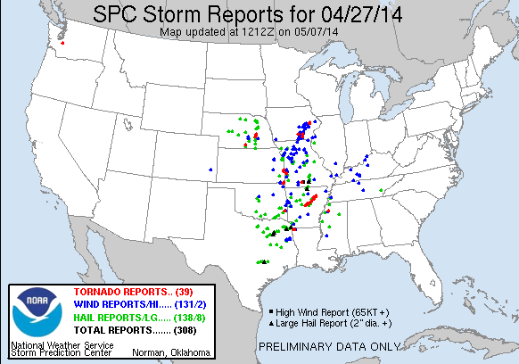
Meanwhile, to our N, several tornadic supercells evolved from the Joplin area northward toward Kansas City. This was square in our original target area, but we had abandoned it due to the presumed stabilizing effects of the morning squall line. The thermodynamic recovery in this area was nothing short of miraculous, considering the line had swept through merely 1-2 hours prior to when several tornadoes occurred (including one fatal tornado in Baxter Springs, KS).
In nine years of chasing, only a few storm systems have left me as utterly disgusted as this one. There have been HIGH risk busts and historic outbreaks that never materialized, but abandoning the target we'd been eyeing steadfastly only to see it light up puts this one in a league of its own. The following day, this trough would progress eastward and yield a major tornado outbreak in Dixie Alley. In its wake, the Plains would fail to produce any long-lived photogenic tornadoes through at least early June (when I'm writing this), making for the worst chase season in decades. The KS/MO border tornadoes on April 27 may not have been the most spectacular in history, but as the nightmarish season has rolled on, we've had to come to grips with just how costly our last-minute change in plans this morning really was.