Plenty of hype to go around, but not much else, as a squall line takes shape in the Dallas area instead of supercells.
In a way, this was a bit like deja vu from Mar 30 - heading south into TX towards a warm front with lots of stratiform rain and cool temperatures from the Red River north. However, it appeared this time that instability south of the boundary would be more robust, and shear was simply phenomenal. Therefore, there was considerable excitement in the chaser community for a potential significant tornado outbreak over N TX. I had scheduled an interview for a summer internship for 1:00pm several days earlier, not realizing the possible magnitude of the event, so I became quite nervous as the day approached. Most chasers departed by late morning to get into position; I was able to get back, change out of my coat and tie, and hit the road with Aaron Gleason by 2:00.
We decided to skip checking data in Ardmore in the interest of time, since the warm front was still draped farther south near I-20. Right as we had been leaving Norman, an impressive supercell was showing up on radar south of Wichita Falls, tracking northeastward towards SW OK. We would later learn that this produced a brief but large wedge tornado near Seymour (by far the best action of the day, unfortunately). In any case, we watched for signs of that storm to our west on our way down I-35, but the stratus and rain kept visibility low; plus, we knew the storm would likely fall apart upon crossing into the cool airmass over OK anyway.
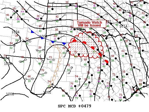
We pulled off the interstate in Gainesville for a data check, and discovered that a portion of N TX had been upgraded to high risk on the 2000 UTC outlook! This was the first high risk of the year outside of the SE US. It appeared SPC believed the highest tornado threat of the day would reside near and east of I-35, including DFW, where a massive traffic nightmare (or, to be more specific, redneck convergence - just kidding of course) was unfolding thanks to a big NASCAR event at Texas Motor Speedway. While avoiding the metroplex is preferable on any given chase day, we knew getting anywhere near the cities simply wasn't an option today, which was quite a dilemma. On the one hand, convection was lightning up along the dryline at the time, which was still a few counties to our west - in fact, Bryan called us from near Mineral Wells and reported explosive development and a possible wall cloud. However, by choosing to drop southwest towards this activity, we would essentially be putting ourselves out of the game for any later activity east of I-35 in the high risk area, since the only quick route east was I-20 through DFW. However, the temptation was too much, so we decided to blast southwest towards Decatur.
We arrived in Decatur about a half hour later and attempted to get wifi; despite the decent size of the town, we failed to at every place we stopped, so I eventually gave up and headed south towards Weatherford out of frustration. Traffic along the way was an utter nightmare; I can't even count how many pickups and trailers doing 10 under we were stuck behind. Leave it to Texas to make an already stressful chase ten times worse by hordes of idiot drivers. The storm Brandon and Bryan had been following around Mineral Wells was now approaching our path. We suddenly noticed darkening skies to the west, and before long, we were under a fairly ominous base as we neared Weatherford. The terrain in this area was poor at best, and apparently gets even worse as one heads west towards Mineral Wells with abundant trees and hills - I would definitely advise chasers to avoid this section of N TX unless absolutely necessary.
It took us probably half an hour to get through Weatherford due to dense, stupid Texas traffic. By the time we got on I-20, the storm was exiting to our east, and we saw on radar that the earlier supercells had rapidly congealed into a nasty squall line that extended all the way from west of Gainesville to well south of I-20. Bryan relayed advice from other chasers to head south as the activity would be "more discrete" there, so we did, but judging by the radar I knew it still wasn't discrete enough to be exciting. As we made our way towards Cleburne, we began hearing radio coverage of tornado warnings for Tarrant County. In a nasty twist of fate for chasers, an embedded supercell had developed within the now-raging squall line in the worst possible spot: right over Ft. Worth and the NASCAR mess. A tornado touched down near downtown and did moderate damage, and very large hail was reported across a good swath of the metroplex; of course, all but the hardiest of chasers had no choice but to let it go, since chasing in big-city traffic is not exactly safe nor pleasurable. At Cleburne, we decided heading any farther south was simply futile, so we rejoined Brandon and Bryan who were approaching from the southwest and began making our way northeast to the Dallas loop, in hopes of catching the tornadic storm as it exited the metroplex on the east side. After an hour or so, we finally made it to I-20 and observed frequent lightning to our east with the storm, but visibility was not good enough to make out storm features as light faded. Aaron and I made a pit stop in Terrell and took another look at the radar; seeing that the storm was now less impressive and that it was already dark, we called off the case and began heading home.
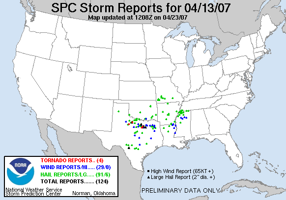
Obviously, a very disappointing day for a high risk and long drive through some of the worst chasing areas in Tornado Alley (taking into account terrain, population density, and local driving aptitude). It may sound like a broken record at this point, but these early-season setups with apocalyptic shear but lots of cloudcover in the warm sector are ripe for bust potential, because no matter how strong and sheared the flow is, you need strong updrafts to take advantage of it, and you often don't quite manage that. In this case, the primary issue was strong forcing that resulted in too many storms going up at once on the dryline; this was compounded by the cold front unexpectedly surging eastward and catching up with the dryline, thus undercutting the storms and killing instability. There was lots of talk within the chasing community after this event that the decision to upgrade to high risk and issue a PDS watch was more political than meteorological given the huge outdoor gathering at TMS. While I won't claim to know exactly what was at play in the SPC office, suffice it to say, the high risk did not verify in this particular case!