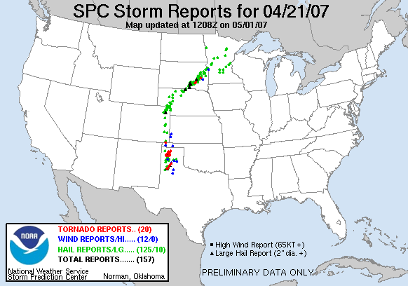
Significant tornado outbreak along the I-27 corridor, but poor decision-making and incredibly bad luck leaves us empty-handed.
Another day, another chase in the High Plains, despite climatology dictating that most of our threats prior to May should be farther east; you'd never know it going by 2007, though. This day, like many others thus far in 2007, looked good from a ways out and drew out large crowds. Predictably, while the threat area initially appeared to be the eastern Panhandle into western OK, the dryline began to shift west with each model run, eventually appearing to hang around the TX/NM border by the morning of. Thus, a long haul to the west and early departure was in order - hey, at least it was a Saturday.
Based on data Brandon, Bryan and I reviewed the night before, our target area was along I-27 between Amarillo and Lubbock, specifically near Plainview. After Brandon was contacted by Gabe Garfield about riding with him and some other grad students, we decided he would go ahead and do that, and Bryan, Trey and I would follow behind in my car. So we left by late morning and began the now-familiar path west on I-40. Cloudcover increased as we approached the TX border, and by the time we stopped in Shamrock for lunch, widespread stratus covered the sky with fairly cool temperatures. Gabe and Jeff reviewed new data and began to suspect that the cap might be a problem to the south, citing an analog of May 15, 2003; for my part, I was simply too lazy and irritable (from a bad experience in the Pizza Hut) to look over the new data. We continued west to Amarillo, where we arrived around 3:00 and stopped just east of town to wait and monitor data. The clouds had cleared out by this time, and while there was a decent Cu field, initiation did not appear imminent.
We waited around for well over an hour, during which time several new cars with OU chasers and even a well-respected professor and researcher showed up. Finally, it appeared initiation was occurring along the NM border by 5:00, so we began heading south on I-27, getting off between Amarillo and Canyon to head west for a clear view. From there, we observed multiple impressive cells exploding to our west and southwest. The southern storm became tornado warned and continued to look very impressive, so we decided to jump on it and head a little farther west.
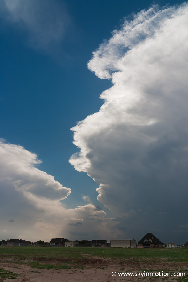
Getting up to the updraft base required some adventures on backroads, during which time I ran over a massive pothole going over 60 mph, unfortunately. We stopped south of Bushland and watched the base pass just to our west, experiencing some very intense inflow that not only kicked up copious amounts of dirt, but also ensured that my tripod wouldn't stay still enough for sharp photos.
While there seemed to be some rotation initially, there was no real sign of a wall cloud, and the storm soon appeared outflowish.
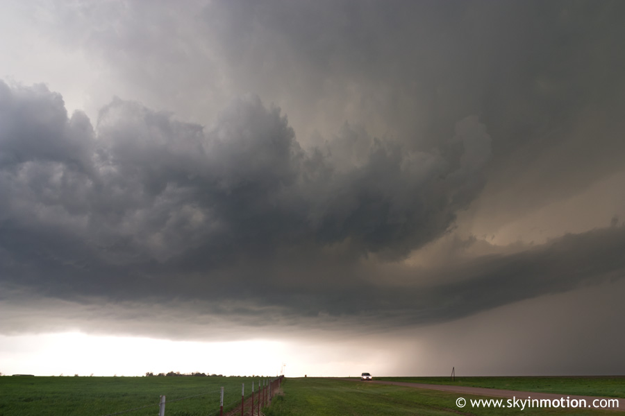
Unbenknownst to Bryan, Trey and I at the time owing to our lack of real-time data, by this time there was a very impressive supercell to the south (W of Lubbock) which many chasers were flocking towards. Our caravan abandoned the storm we were on and dropped a few miles southeast, before stopping again to reevaluate the situation and watch a new LP-looking storm move up from the southwest. I didn't like the very cool air that had settled over our location behind the initial storm, but the group as a whole opted to continue watching and waiting, evidently hoping any new cell developing to our southwest would be golden and we'd be in good position for it. Luck was not on our side, though - after much watching and waiting, we headed north back through Amarillo to get a view of a storm we had let pass us by earlier, but was now tornado warned. We were not able to catch up, though, and the sun was setting, so the chase was eventually called off north of Amarillo.
This was a pretty frustrating day, since several nice tornadoes were reported both north and south of the Amarillo area, where we stayed most of the afternoon. And while the fact that our usual chase group had our sights set on farther south, close to where the damaging Tulia tornado occurred, is a little hard to swallow, I also fully recognize that the more experienced members of our convoy had solid reasons for positioning us where they did, even if they were too advanced for us to understand. Indeed, it seems it was little more than bad luck that none of the storms that formed SW of Amarillo could put down tornadoes like the supercells north and south of us did.