
This chase probably shouldn't have happened, but preceding events led to my stumbling into it by default. Two days earlier on June 22, as I was nonchalantly working on research during the afternoon, my news feed started blowing up with aurora posts from chasers up north who follow that stuff closely. Evidently, an Earth-directed CME was beginning to impact satellite-mounted instruments with readings indicative of a high-end show visible from unusually low latitudes; the only real question was whether these conditions would persist until after darkness set in across the central US. I've casually followed this stuff for years, mainly because of the chatter from other chasers who live in more conducive parts of the country and always get photos that make me depressed. Glancing at satellite, I was amazed to see that the central Plains would be entirely cloud-free, something that can rarely be guaranteed. Between all this and the fact that we're already past the peak in our current 11-year solar cycle, it seemed that if I was ever going to make good on my talk of "chasing" the northern lights, this was the time. I scrambled to pack my bags and get on the road to increase my latitude as much as possible by nightfall -- and because I'd had an eye on June 24 for a possible last chasing opportunity this season, I made sure to pack extra clothes.
Had the aurora borealis foiled us spectators like it seems to do so often when signs look promising hours or days in advance, I most likely would've driven home that night in disgust, then sat out Wednesday's setup (it didn't look all that great by the morning of). That's exactly the scenario I was almost banking on as I drove northward Monday evening. Instead, I witnessed faint greens and reds in the northern sky at twilight even with the moon high in the sky -- and as true darkness set in, an exceptionally nice display for 39°N unfolded as I watched in awe from near CNK. Needless to say, I was reluctant to turn around for home before I was near-certain that this rare window of opportunity had shut. That didn't happen until almost 2am, and with home five hours away, a cheap room in Salina seemed the only reasonable option. Said cheap room proved so uninviting that I accumulated maybe 90 minutes of legitimate sleep by check-out time, so now I faced a quandary typical of my longer-distance chases: do I haul it home, only possibly to turn around the next morning and take the same four-hour route toward the target, spending as much in gas as another night's motel stay would've been? Or do I stay put, only possibly to wake up the following morning to a setup I obviously wouldn't have bothered leaving home for? This happened during my June 4-6 trip, and it turned out that June 5 -- the overlooked, "should I bother staying out so I'm already close for tomorrow?" day -- was by far the most rewarding. There would be no stormy reward on the middle day this time, but there would be an opportunity to recover sleep-wise.
Well, you win some you lose some. At least it had been a good chase year for me up to this point, and the gamble to stay out during the last trip paid dividends. In this case, I committed an extra night's room plus about $40 extra in gas to a chase I wouldn't have found too worthwhile even if it were in NW OK. I left SLN around 8am, stopped for lunch in LNK, then spent all afternoon meandering around SW IA with little enthusiasm -- a cap bust appeared quite likely, with morning convection confining the effective warm front to the I-80 corridor. By 5pm, I found myself sitting across the river from Nebraska City (well S of the warm front, where any possible storms would develop) simply so that the inevitable drive home would be as short as possible; I just couldn't bring myself to pull the trigger and start that drive until closer to sunset, given all I'd poured into the trip. Well, just as my finger was beginning to pull, convection exploded along the boundary about 20 mi. N of I-80. The boundary wasn't lifting much at all, and an SPC MD identified the storms as elevated, but the vis sat loop made me nervous enough to dart off in that direction. An hour later, I was exiting I-80 at Walnut, as the westernmost in a cluster of warm front supercells loomed just to my N.
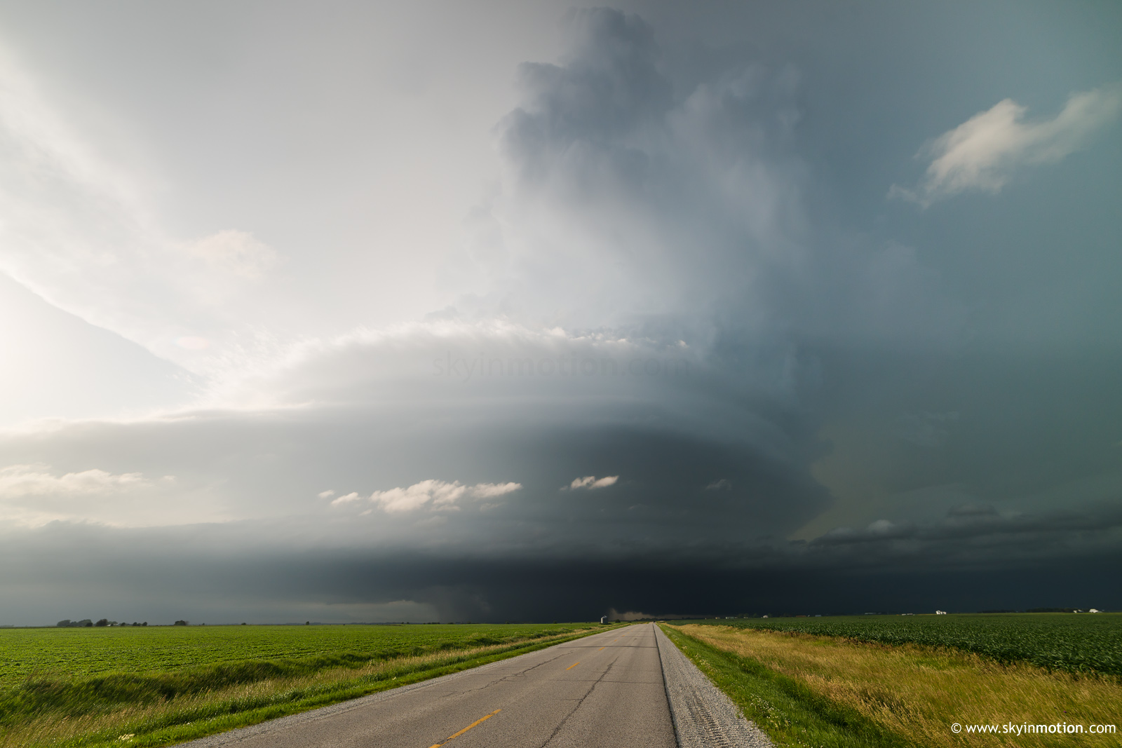
Beneath this beast was an RFD cut and wall cloud as textbook as they come. I sped underneath for a closer look, practically expecting a wedge would appear just in time for my arrival, after an hour-long race to catch up. Even this year, though, that would be too good a fate for me -- especially in Lieowa. The structure shown above was by far the highlight of the day, as I spent the next 90 minutes zig-zagging SE toward Anita, rarely able to get much ahead of the base. Before long, it didn't matter, as it was not only HP but growing upscale into an MCS with the storms to its E. Despite an ongoing tornado warning, I dropped it at Anita around 8:30pm to minimize the pain of the trip home. Eight hours later at 4:30am, I was in my own bed again -- the above structure shot representing everything I had to show for staying out two extra days and tacking another 1000 miles onto my odometer (which I could hardly bear to look at before this, given how active 2015 was).
There's no question, though, that the solstice aurora of 2015 made the whole thing seem worth it anyway.


