Despite an obvious bust looming, I venture out towards Enid just in case supercells develop behind an early-afternoon squall line, which they don't.
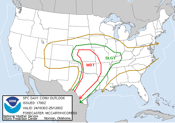
I'll make this one fairly short and sweet, for once. This was one of the most hyped and anticipated chase days of the very active spring of 2007, but simply crumbled before our eyes as the day progressed. A strong storm system moving out of the Rockies was forecast to push a dryline into KS/OK/N TX, with strong shear over the warm sector resulting in the potential for tornadic supercells up and down the dryline - or so it seemed. The 4km WRF runs from the night before showed a linear mess propagating eastward across the threat area during the early afternoon, followed by supercellular development behind it near I-35 during the evening as the dryline stalled, or even retreated a bit to the west. And so began another high-shear, high-hype day that promised to be messy regardless of the tornadic outcome.
By morning, it appeared the dryline was actually advancing eastward into W OK/NW TX at least as quickly as model depictions, a far cry from just about every other setup this year. And this time, it wasn't a good thing, as we needed all the time we could buy to keep the threat in chaseable terrain and gather instability before initiation. That wasn't happening, though. Storms began rapidly firing over NW TX and SW OK as early as 11:00am, and almost instantly evolved into a linear convective system, which then spread northward into north-central OK. Some chasers immediately began calling bust on the moderate risk and 15% hatched tornado potential, while others insisted the show would not be over until evening. I really wanted to believe the latter, but it certainly wasn't looking like a fun day from a chasing perspective. Brandon and Bryan left around noon for the stuff in SW OK despite its linear nature, while I refused to bite on it since it posed no tornado threat and promised to be a deluge of rain - in other words, no photo opportunities either. I was extremely bummed and still needed to turn in some homework early for a 3:00 class just in case things got interesting, so I headed up to campus and did that, then ate at the union while continuing to monitor radar and data. The line of convection had moved off the dryline by this point and was nearing I-35, but in its wake were cooler temperatures, lower dew points, and veered surface winds, even ahead of the dryline. I came home and kept feeling the urge to jump in the car and head up I-35 towards Blackwell to Wichita just because there hadn't been early convection to screw that area up yet, but I also kept remembering the possibility of new activity along the dryline in OK later, so I sat tight in Norman.
By mid-afternoon, SPC and NWS OUN were beginning to hint at a very conditional potential for renewed initiation along the dryline from Chickasha to Enid, so I decided to head northwest (Bryan and Brandon were in Enid, so I figured I'd probably meet up with them if nothing else). I stopped in El Reno for a look at data - no developments on the dryline in OK. Stopped again in Kingfisher - still nothing. During my drive up US-81, I was under anvil debris from the big line to the east, and it seemed to stretch back west to at least the surface dryline, inhibiting insolation where we needed it most. Figuring I had nothing to lose at this point, I continued to Enid where I stopped at the Days Inn to see Bryan and Brandon. It wasn't long before we all agreed the day was a lost cause, so we began heading home. Before leaving, we had noted on radar development along the dryline well north in KS from east of Medicine Lodge to Salina, but figured it looked too messy and linear to be worth any additional driving. Turns out the tail-end charlie became a beautiful LP that put down numerous small tornadoes. Oh well.