Good fortune lands us a unique hose on a messy day, then we encounter every hindrance imaginable to getting home.
Observed 1 tornado.
Curtis McDonald and I targeted the I-40 corridor from Amarillo to McLean. We were right under the base of the initial storm W of Clarendon (3:30-4:00pm) within 20 minutes of initiation, experiencing golfball to tennis ball hail along US-287. The storm's updraft was simply explosive, appearing as crisp and vertical as anything I've ever seen in the Panhandles before. Almost immediately it developed an impressive wall cloud and we thought tornadogenesis was imminent. But just as things were ramping up, another updraft exploded in its inflow. And so began the story of the day.
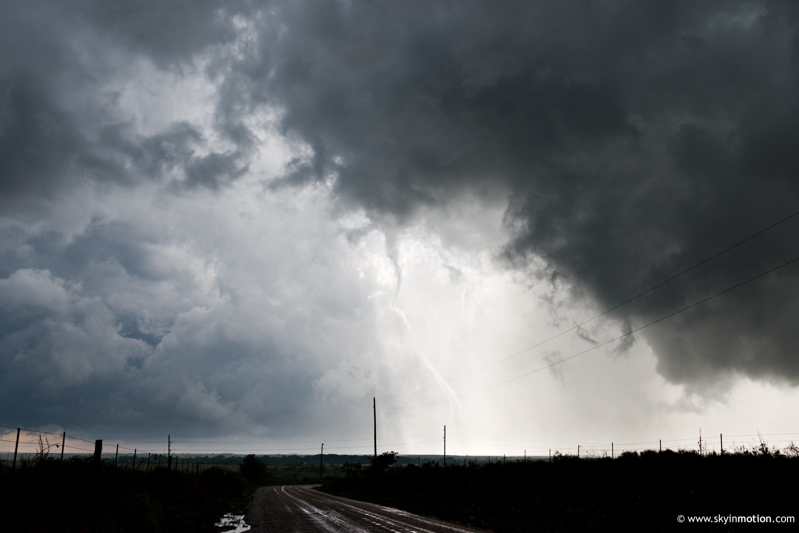
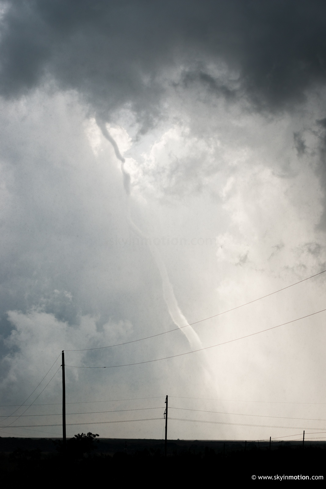
I lost count of how many new storms developed in the area just SW of Clarendon, near the Donley-Briscoe-Hall Co. corner, over the course of the afternoon and evening. There almost certainly had to have been some type of orographic enhancement that favored this spot in conjunction the day's low-level wind field. Every single time, the new cell would quickly attain 50kft tops on radar, develop a notch and appear primed - only for the process to repeat with a period of 20-30 min, leading to a complete convective mess. Around 5:30pm we had all but given up, and decided to gas up in Clarendon before bailing S for similarly messy storms around Lakeview. No sooner had we finished our pit stop than did a couplet and tornado warning appear to our immediate NW near Howardwick - around where we'd been driving in circles for an hour prior. We raced back up and caught the entire life cycle of the "main" Howardwick tornado around 5:40pm, but most of its cone phase was compromised by poor viewing conditions as we traversed hills E of Greenbelt Reservoir. In hindsight, simply beelining to the park area on the E side of the lake would have been the smart move. We eventually stopped about 2-3 mi. ESE of the vortex as it entered its rope phase, which was perhaps the most interesting and photogenic, featuring clearly visible chaotic descending motion.
Afterwards, the convective evolution in this area immediately reverted to the cluster that had seemed evident beforehand, so we shot S toward Brice. Unfortunately, we were about 5-10 min. too late to be in good position for the strong (but partially wrapped) Lakeview tornado that occurred shortly after 6pm. This became obvious as we attempted to catch the cell from the backside and hook slice, but continually found ourselves nearly blown off the road by RFD and some of the most blinding rain I've seen since... well, most of my 2015 chases, I guess. Before long, the tornado was done, the cell was becoming extremely HP, and we were struggling to make our way back NW from Plaska to TX-256. During that drive, flooding became increasingly worrisome, and by the time we were 1.5 mi S of TX-256 things came to a head: a torrent of clay-red water rushed across our paved N-S road for nearly a quarter-mile stretch that we simply couldn't risk getting caught up in. As a result, we sat helplessly between rushing rapids on either side of us as extremely heavy rainfall continued unabated for over half an hour. Sometime close to 8pm, we finally resigned to attempting the roundabout route S toward Estelline and Childress (since radar indicated temporarily lessening rainfall in that direction). We cautiously made our way down to TX-86, then wasted a good 10-12 mi. getting E toward Estelline before encountering a road block and downed lines. Now after 9pm with twilight fading, our only option was to backtrack SW to Turkey, then make the 60-mile trek back to I-40 at Jericho. We pulled into Clarendon at 10:03pm to find the local Subway locking its doors and unwilling to take pity on us, leading to my first (and hopefully last) ever Allsups dinner on a chase. Upon reluctantly inquiring about the assortment of stale corn dogs and popcorn chicken offered there, the cashier replied, stone-faced: "hell if I know; I'd never eat this stuff." Touche. Unfortunately, we did. We made it back to Moore around 1:30am after fighting off a 50-mile stretch of obscene outflow winds from Shamrock to Elk City, which averaged 40-50 mph sustained and blew at least one semi off the road.
All in all, a perilous and exhausting chase day with just about every type of annoyance and hazard imaginable, short of something disastrous like a deer collision. Still, we observed a tornado that was mildly photogenic and reasonably long lasting, which was enough to make it a net positive experience. Seeing images of the more impressive Scott City and Spearman cells on the drive back stung a little, though. Fortunately, the next three days would get progressively better!