Starved for data and road options, we intercept numerous supercells but miss all the tornadoes on a big outbreak day.
Observed 1 tornado.
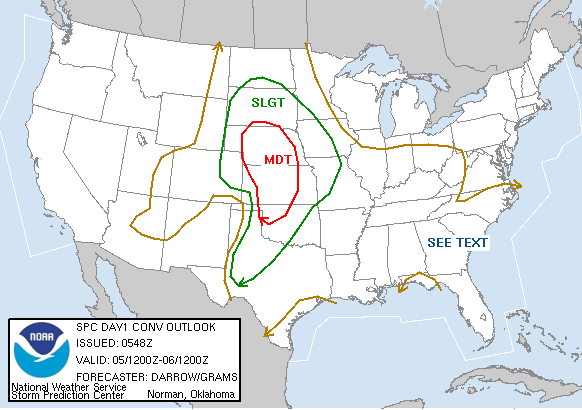
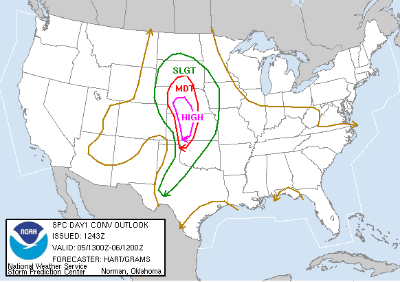
Much-hyped outbreak day with tremendous instability and shear juxtaposed near and east of a dryline all the way from SD to W OK. Brandon, Bryan and I were worn out from the long-distance chase the previous day so we tried to sleep in a little. That didn't work out too well. I got up at 9:00 to check the new SPC outlook and saw not only an upgrade to high risk for W KS, but strong wording about early initiation. So we begrudgingly left at 9:30, hauling up I-35 to Wellington (just south of Wichita), then westward to Medicine Lodge. Upon arriving there, we checked radar and noted impressive supercells initiating along the dryline from NW OK to Comanche County KS, with more linear-looking activity north of there. We blasted westward towards Coldwater, where two supercells came into view to the west. The radar presesntation on the southern storm was more impressive, but since we were closer to the northern storm, we headed westward towards Protection to check it out. On our approach, we observed an impressively large wall cloud that, unfortunately, dissipated by the time we stopped near Sitka.
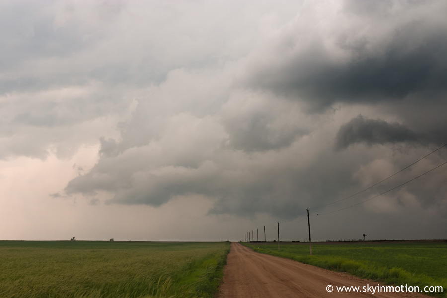
After watching the storm for 5-10 minutes, we decided it would be wise to head back east and hopefully intercept the southernmost storm in the area, since this one wasn't looking too promising. Paved road options were few and far between (which was the theme of this entire day), so we struggled with exactly where to position ourselves, eventually resorting to some dirt roads southeast of Protection. The cell crossed into KS on a NNE heading and passed just west of us.
This storm slowly but surely began to lose structure and weaken, and by the time it passed us seemed fairly hopeless tornado-wise. We briefly allowed it to get away from us near Coldwater before Brandon decided he wanted to pursue it despite the poor visual appearance, since nothing else notable was happening anywhere nearby at the time. We flew east back towards Medicine Lodge, but the storm was already north of us and moving NE into a large gap in road options, so it was a lost cause. Unsurprisingly, about an hour after we had left it, it became tornado-warned and tornadoes were reported.
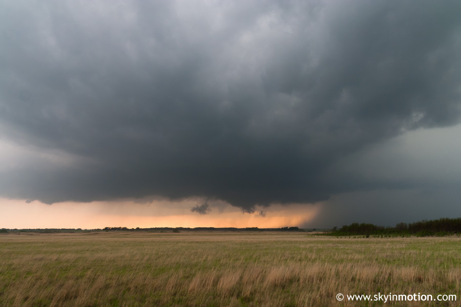
Meanwhile, we were backtracking westward to Coldwater as new development was occurring in roughly the same area it had early in the afternoon - Ellis County OK to Comanche County KS. Major deja vu as we stopped in Coldwater, saw two supercells to our west on radar, and once again headed west to Protection for an intercept. This time, the northernmost storm (which we got under near Protection) seemed more visually impressive than the earlier activity had.
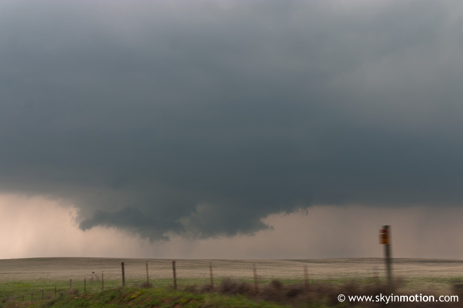
Unfortunately, it showed no strong signs of wanting to produce a tornado as it drifted northward over the town (and away from our paved highway), so we had to fly northeast to Coldwater again. Before doing so, we made the mistake of pulling off the highway in Protection, where we had a nasty run-in with a pompous ass of a police officer who was enraged at the large number of storm chasers in "his" town, and decided to take it out verbally on us. Fortunately, we escaped without a ticket (not that one would have been warranted) and got northeast of the storm for a bit. By the time we got to Coldwater, it was clear we were way too far east and would not have a good view of the base unless we repositioned westward, so we took our chances on more dirt roads. About 5 miles outside the town, the base came into clear view, and a decent wall cloud was taking shape.
At its peak, the wall cloud appeared on the verge of putting down a funnel, but it never happened. The storm lost organization as it moved northeastward, and we began to disagree on whether it was worth following or not. Unfortunately, we decided to turn around and let it get away. Only a few miles into the drive back southward towards Coldwater on US-183, we observed a funnel forming to the distant east with the storm, which quickly touched down and became a moderate-size cone tornado. I wasn't able to get any photos because of the distance, haze, and lack of sunlight (it was now past 7:00 PM). We raced back north towards Greensburg in an excercise of futility, and soon came upon the catastrophic damage from the EF-5 wedge that had passed through that town the night before. Between the debris on main roads in town and the fresh rainfall having turned surrounding dirt roads into mud pits, we called off the chase just south of Greensburg and began heading home, knowing that although there were now multiple tornadic storms to our northeast, there was simply no way of getting to them in time. Plus, it was dark, which sadly seems to be when all the big-time tornadoes like to "come out" this season.
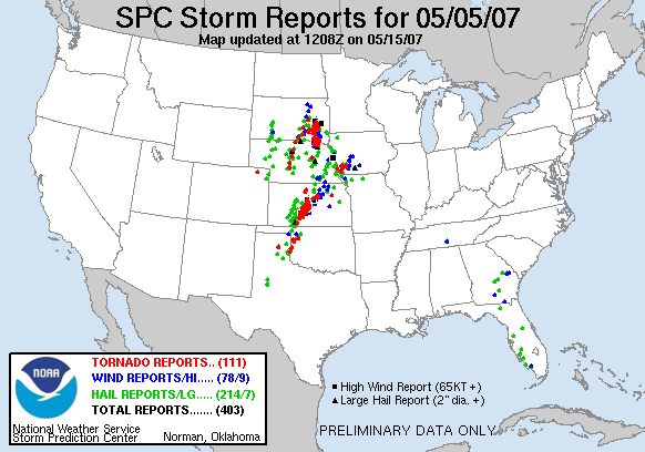
On our way back, we heard reports of multiple tornadic supercells in west-central and northwest OK. The most impressive, by far, was located just north of I-40 in Roger Mills County, and ended up producing a long-track, strong tornado from Texola to Sweetwater to Vici. Meanwhile, we had to take a slight detour to get home in order to avoid another dangerous nighttime supercell in Woodward County. We made it back sometime around midnight. This was certainly one of the longest and most stressful chases I've experienced yet, exacerbated by the fact that we failed to see any tornadoes from a reasonable distance on an outbreak day with nearly 100 twisters reported on the Plains.