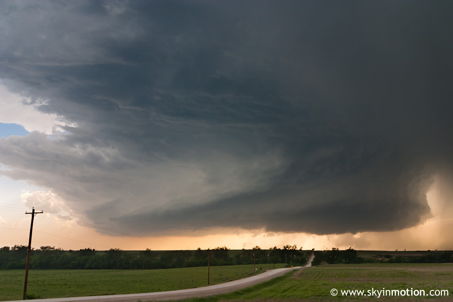
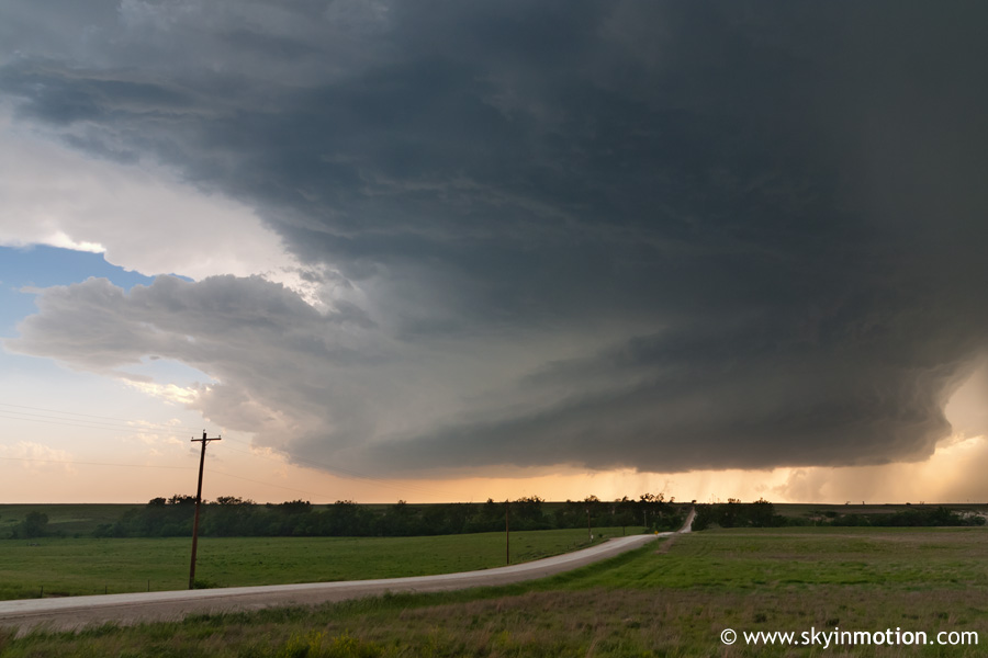
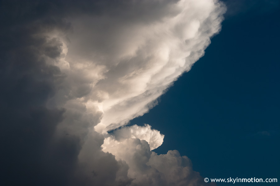
Gorgeous supercell near Hill City, Kansas, provides exceptional structure and a nice tornado.
Observed 1 tornado.
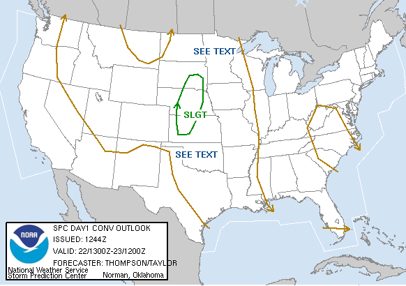
After the crazy outbreak sequence of May 4-5, convection quickly subsided on the Plains, and stayed that way long enough that some of us began trying to get chasing off our minds, fearing the season might have come to a premature close. However, models began showing a trough affecting the Plains around this date from several days out, reviving excitement once again. Weak mid- and upper-level flow, something that had not been an issue for many other chase days in 2007, was expected to plague this setup; in addition, less-than-stellar surface moisture was forecast ahead of the dryline - one of many reasons having cold fronts still crashing through the Southern Plains in May sucks! Still, the overall synoptic situation with a surface low tracking through NW KS, a fairly sharp trailing dryline ahead of a cold front, and respectable shear, favored a very chaseable day on which isolated supercells could be expected.
I was able to get a day off work at my new job to chase; I had been determined to chase this day from as early as the middle of the previous week. But by Monday night, decreased dew points and resultant stronger capping on the 00z NAM made me wonder if I should've even bothered, especially with gas prices as high as they were. Plus, I thought I might have to go solo, too, until Brandon called around 11pm and told me he was on his way back from Joplin to chase. We decided then that we'd both go regardless of what the models showed, unless the situation looked downright awful by morning. We were hoping for an upgrade to moderate risk on the 0600 UTC outlook, but that didn't happen, so we didn't go to bed with particularly high hopes. By morning, the SPC outlook remained the same, but the RUC and 12z NAM improved low-level moisture fields markedly, which boosted our confidence.
My plan was to target the area from Woodward to Beaver to Dodge City - along the southern portion of the dryline, away from the triple point - since parameters were favorable for tornadic supercells there if capping could be overcome. Not only that, but I didn't want to stray too far from home since I had to be back for work the next day (that was about to become a problem - more on that later). Brandon agreed that hanging out to the south of the "obvious" target could prove wise if the cap could be overcome. After discussing the situation with some other chasers, we decided an initial target of Woodward would suffice, from where we could drift north into SW KS if necessary - but preferably avoid shooting way up towards I-70, given the distance and our need to get back home at a reasonable hour.
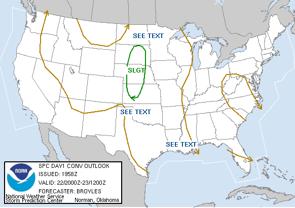
We left shortly after 11:00 and made it to Woodward by 2:00. Low clouds around Norman and OKC had quickly given way to mostly clear skies west of El Reno, then completely clear skies in Woodward. I grabbed lunch at Subway, then we camped out in a motel parking lot to get wifi. Current observations indicated the dryline was still well west, from Garden City to Liberal to Amarillo, although moisture was mixing out pretty badly immediately ahead of it. I knew we should probably head west or northwest since any southern activity would develop right on the dryline, but we decided to wait for the 2000 UTC SWODY1. It came out unchanged: a bullseye of 10% unhatched tornado probabilities over west-central and NW KS, with the slight risk cutting off north of the OK/KS border due to capping concerns. As much as I wanted to believe we might have a shot at repeating May 4 and 5 WRT tornadic supercells developing farther south on the dryline in what had looked to be a capped environment, it only took a brief glance at the crystal clear skies around us to indicate otherwise. So on that note, we began heading up towards towards Laverne, knowing we'd probably need to continue on towards Dodge City.
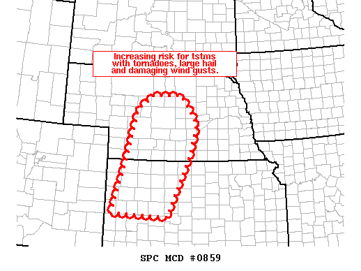
I should mention that we had been completely shocked to see the new day 2 outlook upgraded to moderate risk, indicating the possibility of "strong tornadoes" from NW OK to north-central KS. What?! Only a day earlier, it had looked like the cold front would be crashing into OK that day, with a squall line at best taking shape in the limited instability. I guess we never learn, since almost every trough this year has slowed down markedly from early model progs. Now I was pretty disappointed that I'd need to be back at work the next day, seeing as Wednesday might offer even greater potential now. Well, that was about to be "fixed" due to what mother nature had in store for us later in the evening.
We didn't even bother stopping in Laverne for more data, since deep blue, clear skies persisted. Just after crossing into KS, we started to make out what appeared to be developing convection far to our north. We continued north, observing very sparse cumulus to our west along the dryline, and hoped maybe new initiation could occur closeby, but there were no signs of it. Meanwhile, as we neared Dodge City, the storm way off in the distance began looking more impressive. We bypassed DDC and kept heading north, away from our original target area. Though the exploding top and backsheared anvil on the storm was getting me excited, I also started to realize it would be a loooong drive back if we were already to Dodge City and pursuing something on the northern horizon...
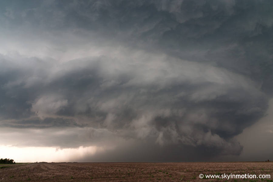
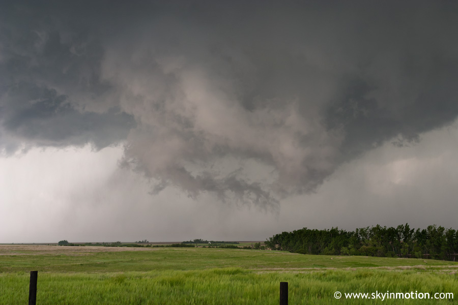
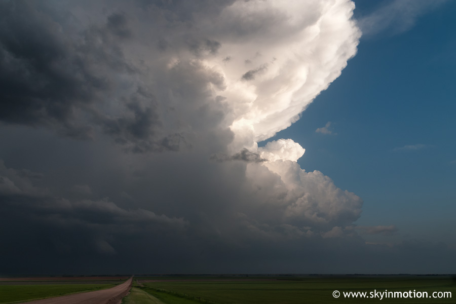
Northward and northward we went, increasingly restless since the storm itself was moving northeast, making catching up a slow process. We had to stop in Ness City for gas in preparation for the intercept, but quickly made up for lost time. As we neared I-70 at WaKeeney, the base gradually came into view - and man, was this thing gorgeous. And it was about to get a lot better. We got through town and continued north a few miles, then pulled off on a dirt road to watch in awe as this striated beast drifted ever so slowly northeast about 15 miles west of our position.
I couldn't get enough of that vault on the north side!
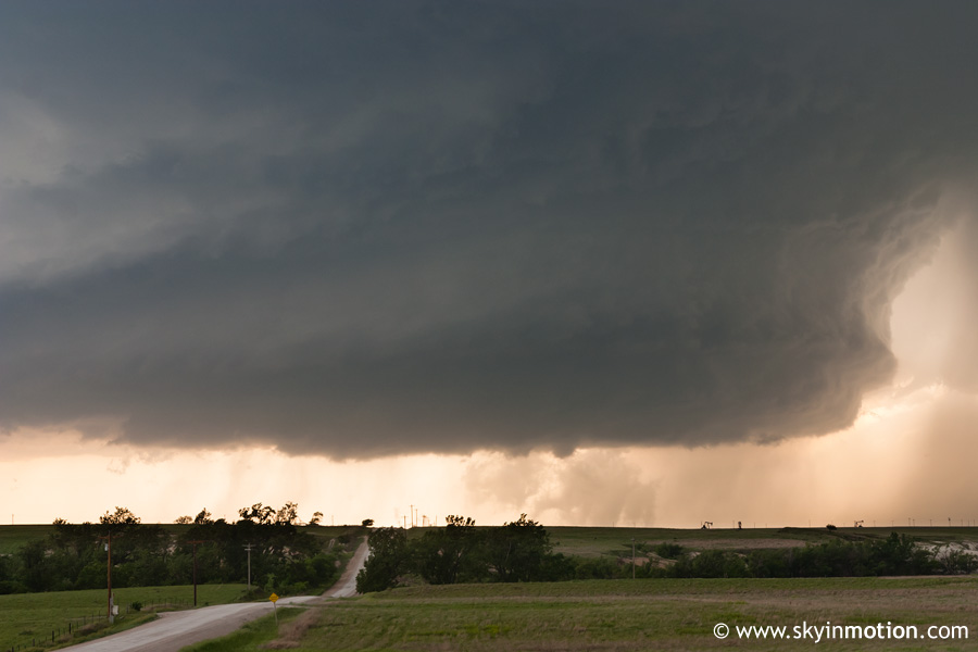
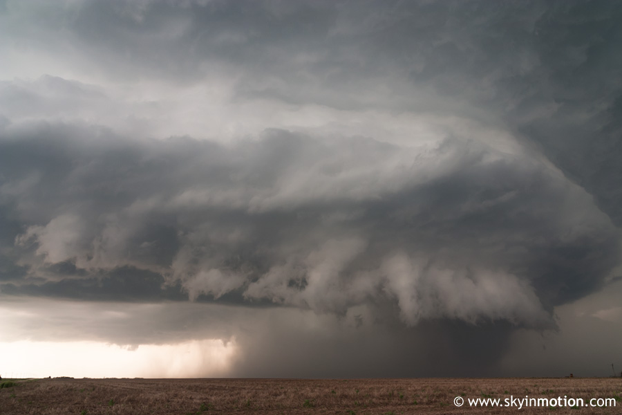
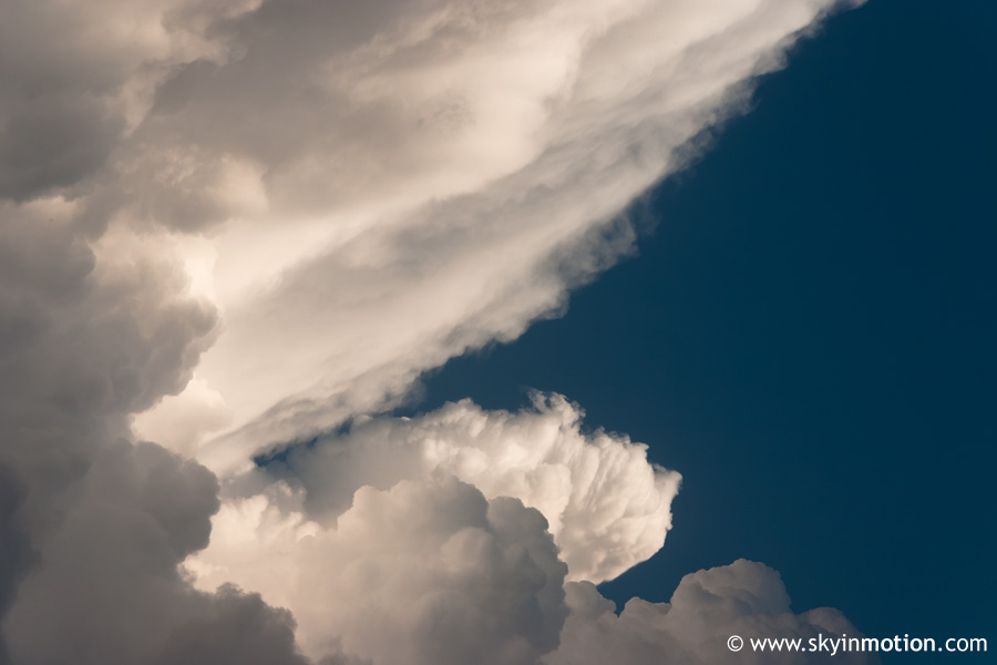
Needless to say, this alone would've made the drive worth it. Wow. We meandered around on backroads northwest of WaKeeney for the next half hour or so, and the storm started to look slightly less organized and perhaps on the verge of becoming HP. Brandon started to suspect there was new activity going up to the southwest, so we got back on US-283 and started making our way south for a look. We'd barely moved at all before this jaw-dropping sight unfolded out our west windows, necessitating another stop, of course:
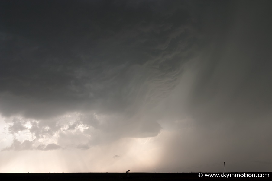
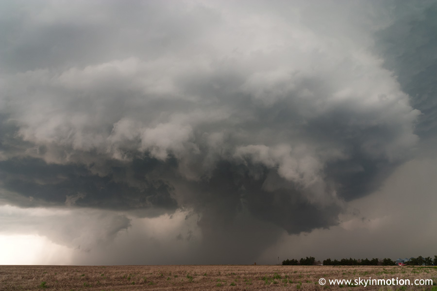
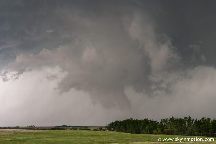
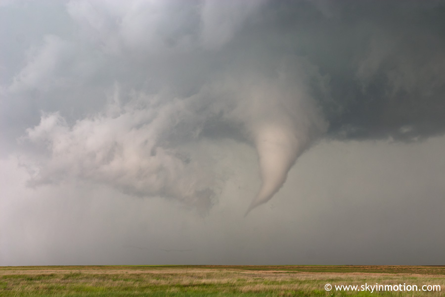
While Brandon was not too excited about the tornado potential, I jumped out of the car practically before he could even stop and scrambled to setup my tripod for the incredible structure. For the next five minutes or so I snapped probably ten or more photos of exactly the same scene. just because it was too awesome not to. While Brandon was filming from back in the car, he received a call that the storm had become tornado-warned again. This seemed surprising to both of us - for about ten seconds. Then, seemingly out of nowhere, an impressive wall cloud appeared just a couple miles to our north-northwest. If the wall had been there before, it was obscured by the precipitation and/or the shelfish feature in the previous photos.
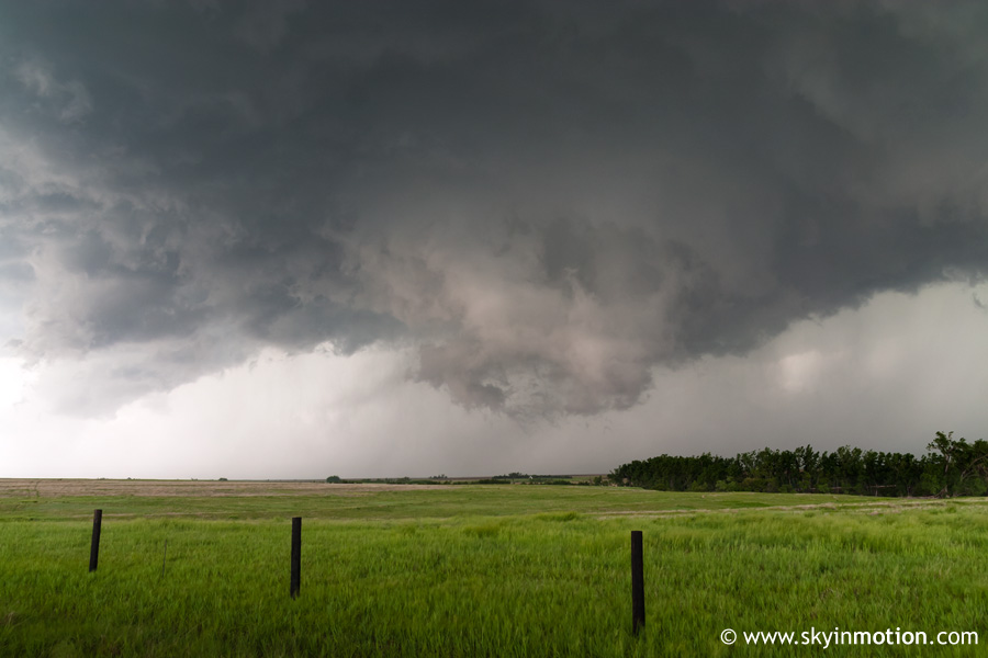
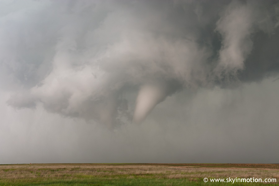
It looked so impressive and was so unexpected that we could barely contain ourselves as we raced north up the dirt road about a mile, before pulling over to watch it churn ominously over a field directly north of us.I've had my share of false alarms in the past in proclaiming a storm on the verge of tornadogenesis, but this time I could just feel it. Then again, I think anyone probably could watching what we were. Since the storm was moving northward away from us (albeit not too quickly), we quickly returned to the car after less than a minute of photographing/videotaping the wall cloud to continue northbound. At approximately 7:15pm, a funnel descended and we observed a debris cloud quickly appear about a mile to our north-northwest while driving up the road. Unfortunately, it was moving at a surprisingly good clip. I didn't even bother trying to take ISO1600 shots out a bug-covered windshield, though in retrospect I probably should have. We stopped about a mile up the road from our previous position to watch the tornado churn a couple miles north of us.
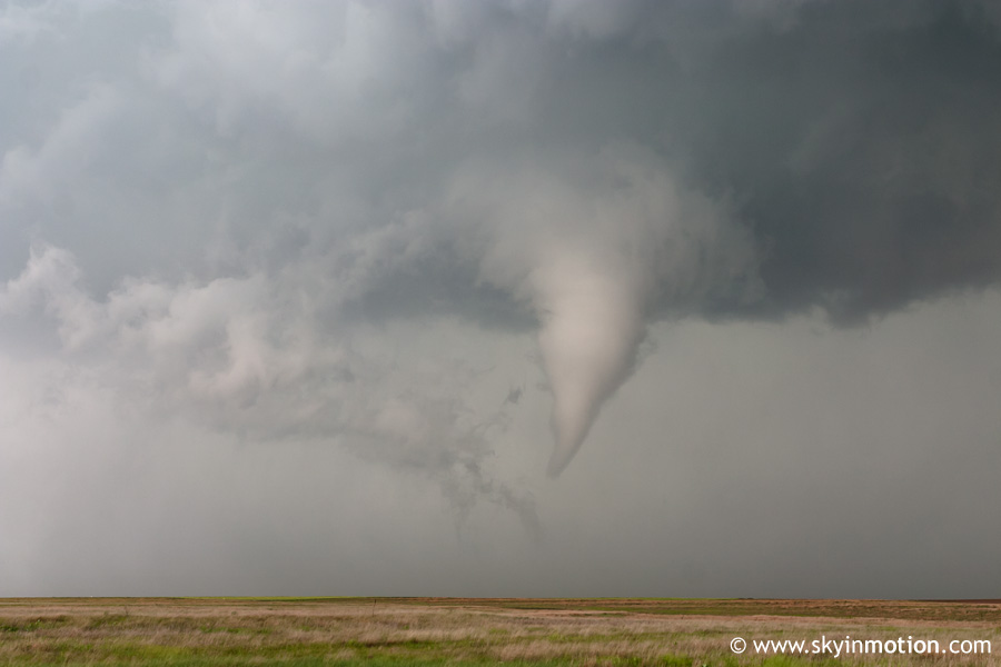
The debris cloud, obviously, is not visible in these shots, probably because of the small rise in the terrain in front of us. Bryan was viewing the tornado from the east on US-283 and reported that at least some debris seemed to persist throughout most of the duration of the tornado, so I'm pretty sure it was still on the ground during those photos.
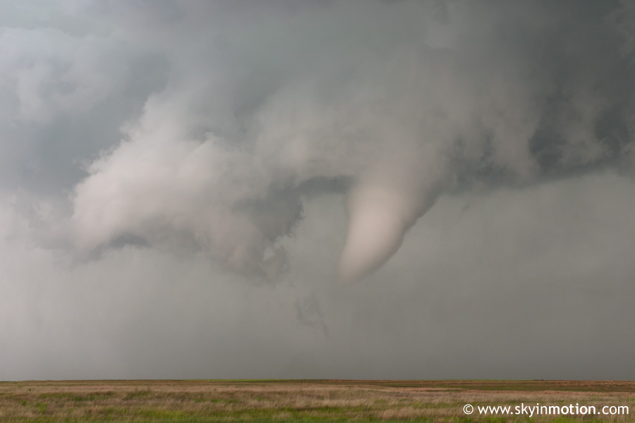
As the meso and twister began to pull away to the northeast, we came under the intense RFD. I've been dying to view a tornado from the southwest (non-backlit position) all season, but obviously the tradeoff is tripod-crushing winds in that area of the storm. Sure enough, the wind picked up from nill to 25-30 mph almost instantaneously; shortly thereafter, we observed gusts to at least 60-70 mph that forced me to fold up the tripod and kneel down on the ground to protect my stuff. In addition, it was a dry RFD, so compressional warming resulted in a near-instantaneous temperature rise of 5-10 deg. F (or possibly more), which seemed to burn my eyes - I guess because of the corresponding decrease in relative humidity maybe. As soon as the worst was over, I resumed my tripod duties and got a few parting shots of the tornado before we jumped in the car again.
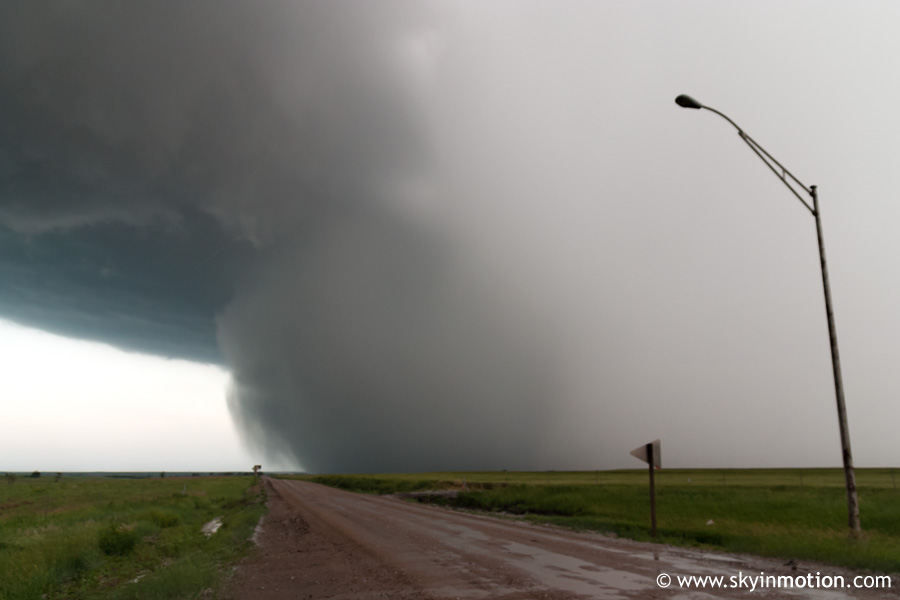
We now headed eastbound towards US-283, watching the tornado rope out several miles to the northeast as it too approached the highway. We were a couple miles from the road, but it felt like an eternity getting there, because we quickly began sliding uncontrollably in the mud - it wouldn't have been quite as concerning if it were just nice wheat fields on both sides, but there were also "nice" 6-8 ft. ditches to worry about, so it was a harrowing ride. Though I was almost certain in the worst of it that we were doomed to an evening of sitting upside-down in a ditch. waiting for the first local to pass by and call for assistance, Brandon managed to keep things (relatively) under control and we emerged on the highway just in time to see a new meso forming immediately to our east. After a few minutes, it seemed to be obscured by precipitation, and everything looked considerably more messy than it had - things were starting to go linear, at least in our area. We then had the pleasure of attempting a core-punch to get back south to I-70; (literally) blinding rain, moderate-size hail, and a call from Bryan informing us that KGLD was indicating 3.5" hail about to cross the highway just to our south quickly forced us to pull off on the shoulder and wait about five minutes before continuing on.
When we resumed the southward journey to WaKeeney, the hail had still not let up entirely, and unbenknownst to us, a new hail core lie just to the southwest of town. Our relief upon reaching town quickly turned to disdain, as a torrent of nickel-to-quarter-size hail moved over, forcing us under the I-70 overpass (I was pretty shocked no one else had staked out the spot before our arrival, and no one even attempted to join us during our five minutes under it!). As it let up, we crept out, and I noticed a large lowering with visible rotation immediately southeast of us.
A puny column of "scud" I had my eye on was actually rotating very visibly about a vertical axis for at least 30 seconds, and I almost thought we were about to score again, though I should've known better since the new updraft had zero separation from the old one to the northeast. While I was focused on that, Brandon, who was less excited about it to begin with, pointed back to our southwest and informed me we'd probably need to get moving, lest we want to find out what it would've been like to punch that 75 dBz core earlier. I turned around, and it didn't take long for me to agree.
I still thought that area of rotation to our east looked interesting, but it was plain to see that a precip-free view was not in the offing, so we headed west on I-70 after hearing that a new tornado-warned cell existed a county west of us. After a couple miles, it became visually obvious that reaching it before dark was not going to happen; plus, a very impressive updraft appeared due south of us, part of the backbuilding line we had just escpaed from under.
We pulled off at exit 120 to watch that as the sun reached the horizon, along with an increasingly impressive CC lightning show to the east; eventually, it was simply continous, but sadly there was still just enough light remaining to preclude seconds-long exposures, so I came away with no photographic evidence of it.
I guess about this time, it was finally hitting me that it was nearly 9:00pm the night before I was supposed to return to work, and I was sitting on I-70, closer to Denver than to OKC. Not only that, but the developing MCS to the east that lie between me and home was exploding in both strength and size, and not about to go away anytime soon. To top it off, Brandon, who had driven four hours from Joplin to Norman the night before just to chase, was not about to rush back now that it appeared a second outbreak was in the offing for Wednesday, and everyone else we knew was planning on staying the night in Hays (which, with $3.30 gas, would surely be cheaper than driving home and then out again the next day, not to mention allowing more than two hours of sleep). I still had hopes of convincing him to take me back anyway - for about three minutes. Then we came upon hail piled up on the interstate, and rapidly deterioriating traffic.
A few miles past WaKeeney, the hail had accumulated over an inch, and we could see cops blocking off an entire lane of traffic ahead. For 10-15 minutes, we crept along, finally passing a flipped tractor trailer that had been the cause of the delays. Home free! Or not. We abruptly enterted the back side of the MCS several miles short of the Ellis County line, soon experiencing the most torrential hail, by far, I've ever witnessed. On and on it went. It took over half an hour to travel 15 miles to the Hays exit, during which time a prolific amount of small to medium size hail was despoited on the interstate (and Brandon's car), providing new accumulation. Right on cue, as we reached exit 159 at Hays, the precip shut off as abruptly as it had started. As we stopped for gas in town, lightning illuminated an ominous base to our southwest, and what looked like everyone in town was standing outside their businesses or residences staring skyward. A few minutes later, Hays was absolutely clocked by extremely damaging winds, measured in excess of 80 mph per the SPC storm reports page. We watched large construction signs sail through the air at alarming speeds, powerlines sway violently enough to scare us away from them, and, for once, truly horizontal rain. Later, we would find that several gas stations and motels had been damaged (signs, roofs, etc.). The duration of the high winds was surprising, and it came in two waves with a brief lull in between (just long enough to lure us back onto the roads trying to meet up with everyone else at IHOP, then regret that decision). By the time we ate and the weather had calmed to a reasonable level, it was past 11:00 PM. The drive back to Norman would be roughly six hours, $45 in gas, and zero sleep before a 5am arrival. With much guilt, I reserved a room at the local Motel 6 with Brandon and geared up for a morning drive to the TX Panhandle.