On the infamous and historic "Super Tuesday" outbreak, we intercept several tornadic supercells near Memphis, but traffic and terrain prevent any good views.
Observed 1 tornado.

I'm finally getting around to writing this a few months after the fact, so I hardly remember the details of the days leading up to this event, other than to say it was very strongly hyped - and rightly so. I had small hopes of getting some pre-sunset supercells in E OK the preceding day (Monday), but that didn't quite pan out; at the same time, Super Tuesday began to look historic for more reasons than just the political showdown. As a result, Brandon and I timidly began talks of ditching classes for a marathon drive to the Lower Mississippi Valley for this incredible mid-winter setup. He ended up activating mobile Internet on his phone at the AT&T store for the first time, which proved to be a defining moment in our young chasing career, as well as a huge saving grace the following day! As it turns out, we weren't the only head cases in Norman willing to make the ludicrous drive through some nasty terrain to give this system a shot.
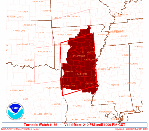
Brandon Lawson, Bryan Putnam, Gabe Garfield, and myself left Norman at 5:00am on precious few hours of sleep, with an initial target between Little Rock and Jonesboro. After stopping for an early lunch (or late breakfast) in North Little Rock, we set up shop around noontime in a gas station parking lot near Fair Oaks, AR, at the intersection of US-49 and US-64. We spent most of the early afternoon watching and waiting as intermittent breaks in the cloud deck brought temperatures into the lower 70s, but initiation of supercellular activity never appeared imminent in NE AR.
By 2:30pm or so, we were growing concerned with the trends on radar, which showed messy embedded supercells over the Ozarks of W AR just ahead of the cold front, while more discrete activity to the east was confined to well south of our position in N LA into SE AR. Eventually, we reluctantly hauled southeast towards Memphis in hopes that the multicellular mess several counties SW of Memphis would get its act together, which it did. Unfortunately, our path to an intercept took us right through the Memphis metro area - at rush hour, no less - just as the cluster began consolidating into discrete supercells.
After crossing the Mississippi at the I-55 bridge, we took US-78 southeast to near Olive Branch, then MS-302 west to Horn Lake, observing a striated but high-based borderline-LP supercell between those two towns. Approaching the MS-302/MS-301 intersection west of Horn Lake, an extremely large and ominous wall cloud came into view behind endless tall trees in association with the very intense supercell that had crossed into MS near Tunica. We dove south a couple miles on MS-301 before stopping as the tight circulation passed just to our north and west, with radar showing an extremely impressive couplet near our position. As it flew NNE at Mach-5 speed, we retraced our path back to Horn Lake to get on I-55 northbound, briefly observing light debris falling around our vehicle just W of Horn Lake on MS-301, about a mile behind the circulation.
We still could not see anything on the ground, but it seems quite likely a tornado was on the ground just to our northeast - either it had lifted as it crossed over MS-301 or we had simply missed it because of the absolutely horrendous terrain/visibility. From the time we crossed the bridge into Memphis onward, heavy traffic and countless stoplights made for an incredibly stressful and frustrating experience. All the while, we were witnessing almost continuous power flashes as the vortex carved a path of destruction through the SE side of the metro area.
As we reached the I-55 northbound ramp from MS-302 east of Horn Lake, we caught a momentary glimpse of what appeared to be a sizeable tornado on the ground ~6 miles to the NE, in the vicinity of Memphis International Airport. Looking back through video, it appears as a large lowering of perhaps half a mile in width whose condensation funnel extended about 2/3 of the way to the ground. Power flashes over the south Memphis area were numerous for a good 10-15 minutes as we raced north to I-240 eastbound. By this time (nearly 6:00), the last hint of daylight was fading, and the storm was rocketing away from us at over 60 mph. We continued northeast to near Cordova, where we stopped for gas and subsequently abandoned the Horn Lake-Memphis-Cordova supercell for good. Inside the gas station, a woman claimed to have witnessed a large tornado nearby less than 15 minutes prior.
Now 6:30 and completely dark, we began heading west on I-40 towards home, and heard reports of extensive damage in parts of the Memphis area in association with the tornado(es) from the cell we had attempted to chase, including at the airport and a mall. Unfortunately, at least three fatalities occurred with this storm, though the night was still young and about to get much deadlier yet for residents of the Mid South. Just as we began settling down and facing the reality of the impending seven-hour drive home, numerous supercells began organizing over a large portion of flat and forest-less E AR - right where we'd needed them all afternoon! With radar now at our fingertips, though, we weren't about to let darkness hamper our chase prospects. We exited I-40 near Palestine, in St. Francis Co., and pulled off of a road just north of town to watch a nice base pass by to our north.
Following this, we dropped southwest to Moro to view a second and more photogenic supercell, which thankfully did not produce a tornado until passing by the town (and, not so thankfully, out of our sight).
As we headed up AR-78 out of Moro and watched the storm quickly leave us behind, a very nice funnel cloud appeared. The photo below does not do it justice at its peak; it was easily halfway descended to the ground, if not farther, for several seconds, and we thought a tornado was imminent. We returned to the I-40 Palestine exit, and I got one final departing shot of the supercell, which was likely producing a tornado somewhere off in the distance by this time. The raging frontal squall line was also fast-approaching from our west.
By this point, nearly two hours had elapsed since we began our pursuit of the nighttime activity in E AR. What was already going to be a loooong and painful concluding drive to our trip had now been delayed to the point of pushing the whole affair beyond the 24-hour mark, a first - and hopefully last - in our chasing history. We stopped on the east side of Little Rock around 11:00 PM for a rather late final meal of the day, Just as we were finishing, another car full of OU chase friends arrived purely by coincidence, which led to a good half-hour of story exchanges on our respective hairy encounters in Memphis. So it was not too long before midnight when the 350-mile final stretch from LIT to OUN commenced. At this point, Gabe took over driving duties to relieve Brandon for the first time in, oh, 20 hours or so. We took a quick look at damage in Atkins (right on I-40 about 60 miles NW of Little Rock), where a long-track EF-4 tornado that went on to wreak havoc on a 120-mile stretch of the Ozarks had originated early in the evening. Though darkness precluded a more productive survey, damage to several homes on the eastern outskirts of town was too brutal to need much light for the point to get across. [Over a month and a half later, I would note significant damage to trees and structures still plainly visible along I-40 a couple miles east of the town while driving home for Spring Break].
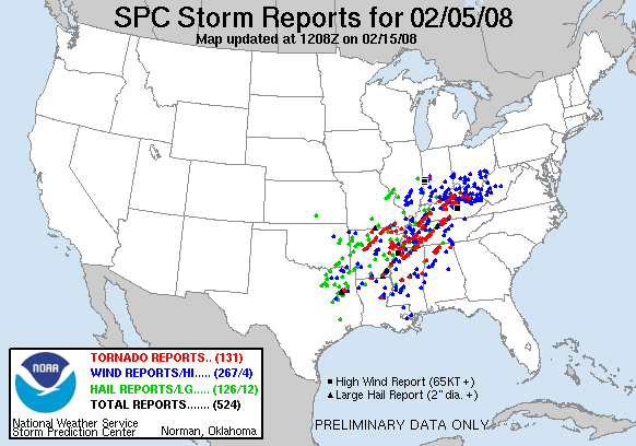
It wasn't long after the Atkins detour that I was simply knocked out cold by the purest form of exhaustion I've felt since - well, since pulling an all-nighter in December studying for a final after spending the preceding days glued to an unfolding ice storm (how many college kids can honestly say the culprit behind nearly all their procrastination and academic downfalls is the weather?). I woke up periodically during the long haul through the eastern half of OK, but was always out again within minutes, even despite groggily hearing Gabe's perpetual amazement as he tracked on radar hordes of prolific supercells continuing to ravage KY/TN/MS/AL well into the night. Already, sobering fatality figures were coming in from the earlier activity in AR, and when all was said and done, over 57 people lost their lives that night, with the greatest concentration in W AR, as well as W and C TN. This ranked it in the top 15 deadliest tornado events in U.S. history, as well as the deadliest since 1985. It's still hard to fathom having chased an outbreak that ultimately caused more carnage than the most infamous of Plains outbreaks, including May 1999 and April 1991. The contrast of the terrible chase conditions and lack of highly-visible tornadoes with the unbelievable damage and human toll of the event was just another reminder of why I absolutely hate Southeast and Midwest tornado outbreaks - as if I needed one! We arrived back at Brandon's apartment almost 24 hours to the dot after our departure, which now seemed ages ago. It was here that I reaped the "rewards" for my choice to wear shorts for the chase (hey, the warm sector was in the 70s and humid!), as I clumsily transferred all my belongings from Brandon's car to mine in the 25-degree readings with a nice, refreshing 25 mph north wind to boot. I felt on the verge of hallucinating for the three-minute drive back to my place, then collapsed for a solid 10 hours or so (missing more classes in the process), but it was worth it in the end to have been a part of one of the more significant severe weather episodes of the decade.