
I just miss a brief tornado near Electra, TX, but catch the great structure that follows near Wichita Falls.
After a series of underwhelming chases the previous week, it was a bit difficult to get excited about this one despite an excellent synoptic setup. Contributing to that was the similarity to the March 30 event that failed to produce any daytime tornadoes: a low-amplitude, fast-moving trough with great directional shear and sufficient speed shear, but slightly lackluster moisture. This time around, moisture was an even bigger concern, thanks to a front that had pushed deep into the Gulf Coast region the day before. Models were consistent in advecting 60-65 deg. F dew points up to the dryline and triple point in W OK, but only in a very "last minute" fashion, a trend that only increased as we neared the event. By Sunday night, surface analyses showed 60 deg. F dew points confined to SE TX, with much of OK seeing 30-45 deg. F readings. I went to bed with a sinking feeling.
Monday morning, the RUC remained insistent on returning decent moisture into SW OK by showtime, and real-time observations were slightly more encouraging than I had expected. Given the almost-ideal wind profiles in place, it was clear that if we had truly sufficient moisture (surface dew points in the mid 60s) this would be a potentially major outbreak, but in reality we would have to settle for low 60s at best. Still, the forecast CAPE axis of 2500-3500 J/kg ahead of a dryline bulge around Lawton and Wichita Falls seemed sufficient for nice supercells with a fairly substantial localized tornado threat.
I hung around Norman until about 1:30, when I made the decision to target Lawton and hit I-44. The triple-point was expected to be a bit NW of there, perhaps in the Hobart-Clinton corridor, but dryline storms were also a distinct possibility, so I wanted to be in position to go for either depending on what actually initiated. Fortunately, storm motions with this beautiful low-amplitude system were forecast to remain under 30 kt., meaning storms would be easy to get to and keep up with. On my way down, I watched 60-62 deg. F dew points slowly creep past the Red River and into Jefferson, Cotton, and Tillman Co., and felt relatively optimistc. Just after I arrived in Lawton around 3:30, a PDS Tornado Watch was issued for the area, indicating the expectation of a localized "cluster" tornado outbreak.
I camped out in a motel parking lot, monitoring radar and other real-time obs, and soon a storm exploded over Wilbarger Co. TX west of Wichita Falls. I was a bit surprised to see convection down there before anything had fired closer to the triple-point, but then again moisture was better down that way which may have contributed to breaking the cap. For about half an hour, I nervously held my ground in Lawton as the storm quickly strengthened on radar; I knew shear was forecast to be better closer to the warm front in OK, and didn't want to fly south and get cut off from later activity by the Red River. Well, by the time 4:30 rolled around and the NW TX activity remained the only game in town, I got nervous enough to start down I-44, hoping that if OK was going to fire it would do so before I made it all the way down to the storm.
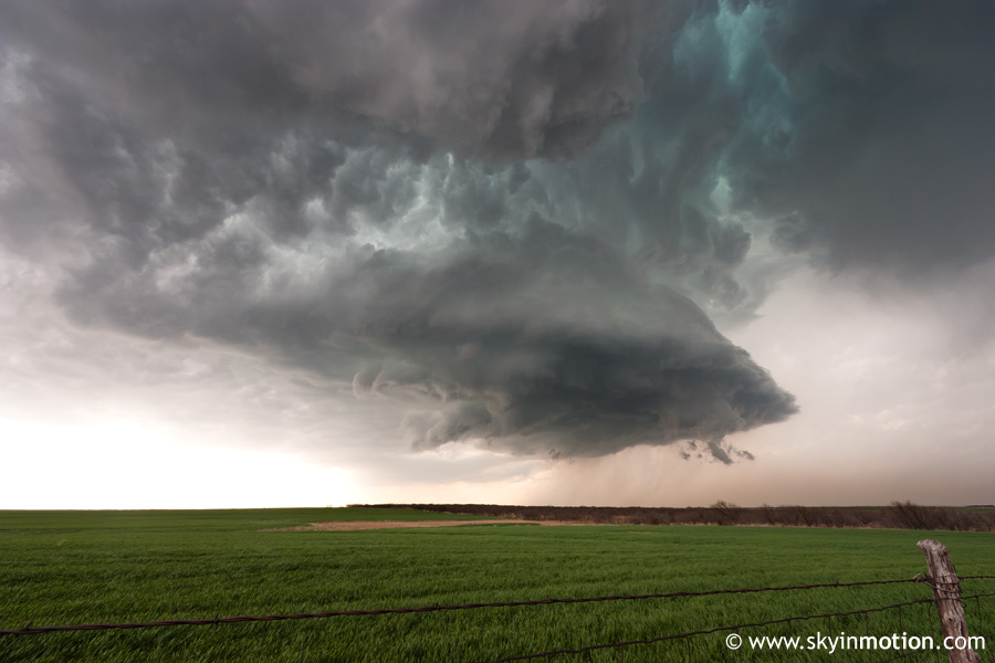
I pulled off the interstate near Geronimo to take one last look at things, and sat there torn for another 5-10 minutes. Then a new radar update came in that changed things in a hurry: nice hook developing on the Wichita Falls area storm with strong rotation apparent. I hopped back on the turnpike and booked it towards the Red River, watching the radar presentation become almost phenomenal for several scans. I had a brief, but in hindsight annoying, hangup at the toll booth in Cotton Co., where the attendant spotted my laptop and wanted a comprehensive update on the situation (even as I told him repeatedly the storm would miss him to the south). By that time, I had a clear view of the updraft about 25 miles to my southwest, with gorgeous structure highlighted by a massive, mammatus-laden anvil overhead and an impressive blocky wall cloud in the distance. I should have stopped for pictures, but continued flying south in hopes of catching any tornadoes - turns out I would be too late anyway.
Just after crossing the river into Texas, I took TX-240 west through Burkburnett (whose streetlights and 30 mph speed zones went on far longer than I cared for given my situation), knowing the updraft base was very nearly following the same road a bit upstream (to my W). As such, I needed to find a suitable road to drop south ASAP unless I wanted to introduce my Civic to some unwanted baseballs. A few miles west of town, I turned southward, increasingly nervous as a 70+ dBz core loomed only miles to my west. Rain increased in intensity, and eventually the inevitable crackling of small hail (up to nickle size or so) followed, but I thankfully made it south of the precipitation core near Iowa Park just in time to view a beautiful updraft structure without having to pay a price in damage for it.
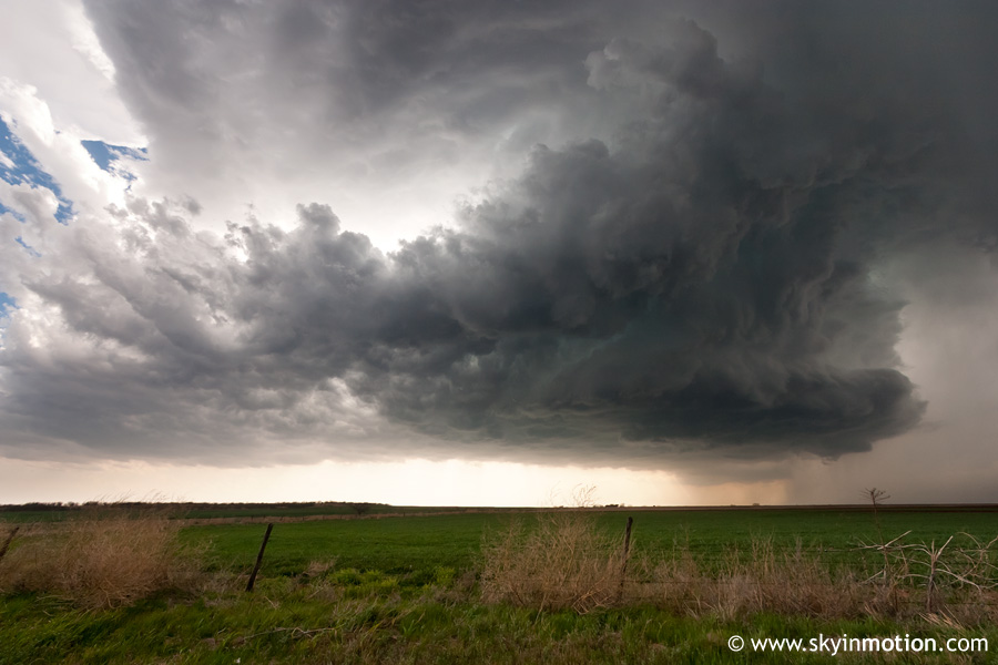
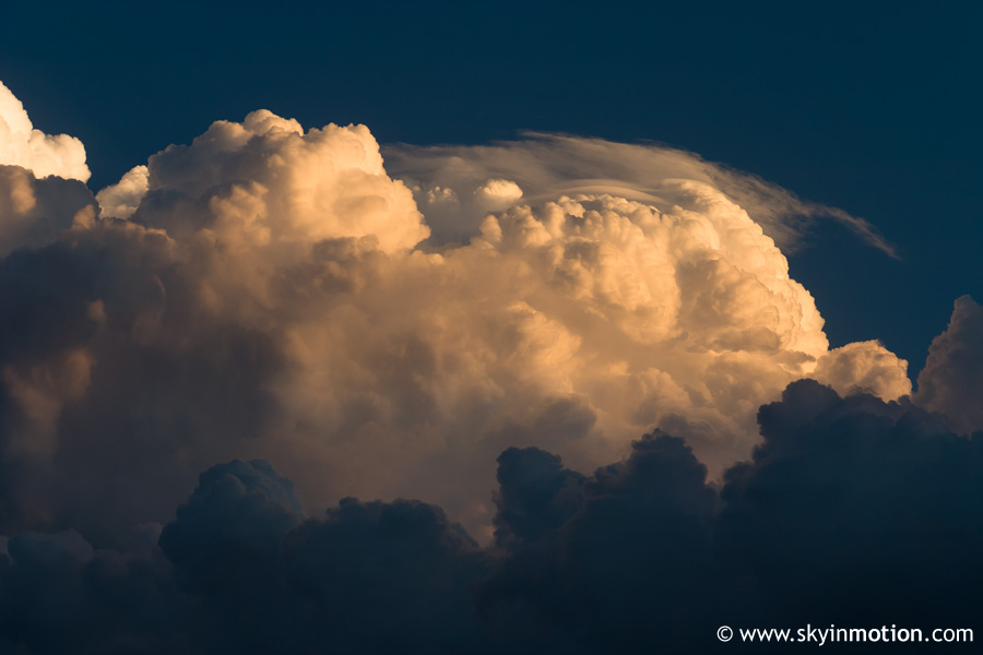
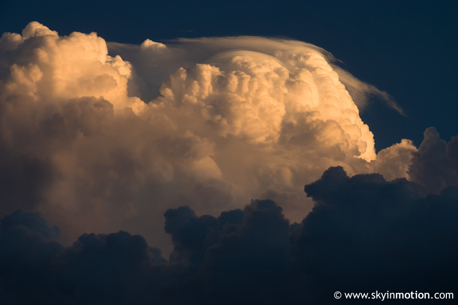
That view (above) is looking due west at the slow-moving beast. Within 5-10 minutes, it was more to my NW, reducing the severe backlighting and making for slightly better photo ops.
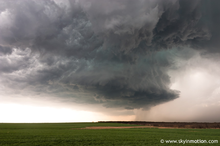
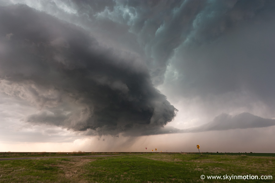
It's honestly a shame I stayed so close; even these shots at 10 mm hardly do justice to the barrel updraft I was now practically right under. Had I known no twisters were to follow, I certainly would have backed off a few miles to the south for a more comprehensive view. Speaking of twisters, a couple brief (and largely rain-wrapped) ones had occurred 20-30 minutes before my arrival near Electra. I was not surprised to learn this, given the very large and ominous wall cloud I'd had my eye on coming down. In any case, the supercell started to look like it might want to try one last time to produce, but didn't get too far.
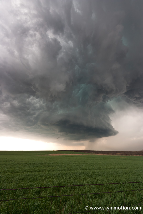
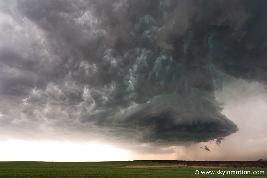
It wasn't long before things started looking a bit outflow-ish, and the base steadily crept higher with time.
To make a long story short, I continued to sit north of Iowa Park for another 15 minutes or so as the storm turned to crap and the base passed to my east, making for poor contrast on what was left. I eventually moved south into town for a parting shot of what was now a decaying shell of its former self.
As the remnants of this cell drifted over Wichita Falls, I began to head back north towards Lawton, where certainly something had to fire eventually! As I did so, I noticed some really nice looking towers well to my southwest, but they were barely showing up on radar and were another 50+ miles in the direction away from home, so I shrugged it off and proceeded north, eagerly awaiting warm frontal activity. Well, that wasn't going to happen. I remembered to check up on moisture again, and the encouraging trends that had been there all day had done a complete 180. I'm not sure if it was mixing out, or mositure being "robbed" by the Wichita Falls cell (as some later suggested online), but instead of surface Td's continuing to increase into the low 60s throughout the target area, I was now seeing lots of 56-58 deg F. type readings with a lone 60 here and there. Not surprisingly, new storms that were finally going up W of Lawton were laughably high-based and benign upon my arrival. I pulled off in a residential area near Ft. Sill, miserable as rain began to fall from a 1500+ m base with sunset only an hour away. About this time, I got a call from Bryan and Brandon, who had fled Lawton for I-44 southward given the increasing convection to the south of Wichita Falls (that I had seen out my window earlier). Bryan reported that it was becoming visually impressive, but at this point it was a lost cause for me; even if I left right away, I'd be down there just in time for twilight to set in, and ultimately pay an extra $10 or more in gas for it.
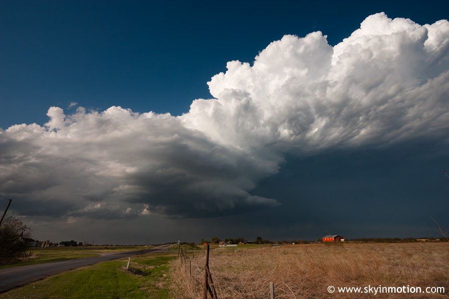
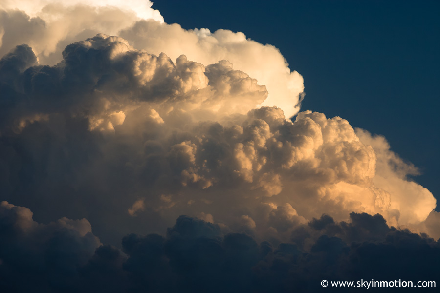
I'm still not sure why I went all the way back to Lawton with T/Td spreads as horrendous as they were north of the Red, but it was a done deal now; all I could do was cross my fingers that the two storms in Wichita and Archer Co. wouldn't put down wedges before dark for me to miss. That didn't happen, but chase accounts and video do reveal some awfully nice structure that I was not party to. As a last resort, I dropped down to Geronimo and took some telephoto shots of the bubbling Cb of the new Wichita Co. cell, which was nicely-colored by the setting sun.
After packing up the camera gear as the sun hit the horizon, I began the not-too-lengthy return trip, stopping for Chick-Fil-A in Lawton (I've had about enough of that city for the year after this day). I opted to take US-62 east out of Chickasha to get home, instead of continuing up I-44 to the H.E. Bailey Spur, since I was running out of quarters for toll. Between there and Blanchard, some nice lightning was going on to my north with elevated storms along I-40, so I stopped briefly a couple times along the way for photo attempts, none of which panned out.
I guess it goes without saying that this was a fairly big disappointment, especially if you take a look at the synoptic map links at the top of the page and then realize there was very little tornadic activity to show for this setup. This certainly isn't the first day with major moisture problems this year, and I guess it's hard to be too surprised this early in the season, but teases are no fun (when it comes to chasing).


