An ominous warm front setup yields one long-lived tornadic supercell, but its HP nature and a poor road network lead to much frustration.
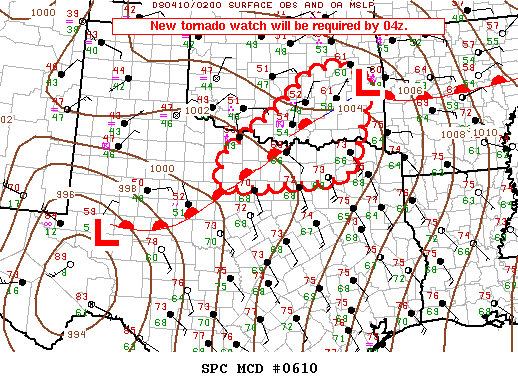
A serious tornado threat was anticipated throughout much of north Texas with this early-spring warm frontal setup. Very impressive wind shear was forecast to overlap moderate instability along and just north of the I-20 corridor, provided that the front actually lifted north during the afternoon. A dryline would remain well to the west, running from west of Lubbock to Midland and south, providing a less reliable but potentially less messy focus for convection. Given the distance involved, we opted to target the warm front in NW TX.
Brandon, Brett Wallace, Bryan, and I took off just after 10:00 AM with a target of Abilene. Despite a lot of crapvection that would make the drive miserable, we opted for I-44 southwest over I-35 south. After stopping for lunch in Wichita Falls, we continued south on the incredibly rural highways of NW TX, only occasionally getting a few moments of Internet access from AT&T. When we stopped to refuel in Throckmorton, it seemed as though we might finally be nearing the surface boundary. We continued south to I-20 at Baird, and by that time, we were clearly in the warm sector with broken sunshine and very moist air. It wasn't long before supercells initiated a few counties to our W and SW, so we quickly moved west towards Abilene on I-20. By the time we were getting into the city, a tornado-warned storm loomed about 10 miles to our west, right in front of us.
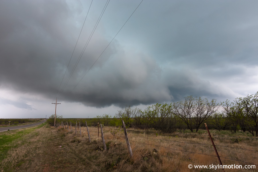
We continued west to near Tye, and then got off the interstate to watch a very ominous storm base pass almost overhead (LCL's were quite low, so it had that warm-front-storm look of being ready to drop a wedge at any time).
As expected, visibility was very poor due to the nature of the storm environment right along the front. We followed the storm northeast for the better part of an hour, frequently confused as to what we were looking at. At one point, visibility became very poor and winds increased to 70+ mph, and we feared we had unwittingly placed ourselves right under a large circulation. My distaste for warm front setups was already growing, and it would only get worse as 2008 progressed! Eventually, as the storm moved into Shackelford County, it appeared it had crossed the boundary to the cool side and thus the threat for tornadoes was likely decreasing. Data coverage in this region was absolutely pitiful, so we blindly continued meandering N and E, knowing that several supercells were in the area and moving in that general direction.
While driving through Shackelford and into Stephens County, we began noticing a lot of leaves and even some small limbs down in the road. This was puzzling, since the storm we were following looked ragged at best. Eventually we reached US-183 about 5 miles south of Breckenridge, and decided to head north into town to see if we could finally get a radar update (by this time, it had been about an hour with no data). But as we approached town from the south on US-183, we suddenly came upon a small line of stopped cars; as we got closer, we saw a semi overturned in the middle of the road, along with downed powerlines on the side of the highway. Unbelievably, a significant tornado had moved through just minutes earlier, and we had been completely oblivious thanks to the visibility and lack of data. We got around the semi and proceeded north into town, only to find more damage, including snapped trees, damaged homes, and unfortunately, dangling powerlines across US-180 east of town. This was obviously the route we needed to take if we were to have any hope of catching back up with the storm.
Incredibly frustrated, we gave up after a few minutes and flew south to I-20 at Eastland as quickly as possible, again without data for a good 25-30 minutes. When we got to the interstate and regained data coverage, we saw that the Breckenridge supercell looked absolutely phenomenal on radar, and that many chasers on SpotterNetwork had somehow managed to keep up with it. I can only guess that they ended up clearing the powerlines from the road only minutes after we gave up waiting, which wouldn't be surprising in the least. In any case, it was already becoming apparent we had little hope of catching up with the storm before nightfall, since we'd wasted almost half an hour moving at a right angle to the storm path (dropping south to I-20 from Breckenridge, just so we could continue east). We rocketed east on I-20 for awhile, but when we hit construction in Palo Pinto County, we knew it was a lost cause. Later on, many chasers would report impressive lowerings near Mineral Wells, but the rain and fog in the near-storm environment prevented any chasers from witnessing a certain tornado.
Upon reaching the Metroplex, we took I-35W up to Denton, then continued north on I-35 where we finally intercepted the storm (more out of inevitability than our actually making an effort) near Sanger. Tornado sirens blared and we watched some interesting lightning-illuminated lowerings as the mesocyclone passed to our N, but no tornado. After the storm had completely cleared the interstate, we continued to Gainesville and stopped for dinner with some other chasers.
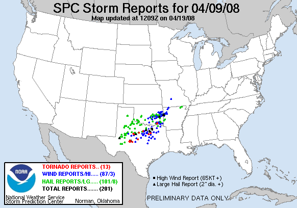
It turned out to be a very frustrating day for all involved, since low visibility prevented anyone from getting a respectable view of what tornadoes did occur. Still, the feeling of coming upon fresh tornado damage on a chase is always unnerving, especially when it's from a storm you've been following with no idea it was producing. I learned that there are few worse places to chase in the Plains west of I-35 than NW TX, particularly along the I-20 corridor from east of Abilene to Dallas. The combination of road network, terrain, and data coverage is just plain abysmal.