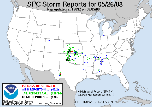
Sticking with a messy HP supercell near Pratt, KS, pays off with a brief tornado.
Observed 1 tornado.
Mildly funny back story: I had chased four consecutive days prior to this, three of them solo and all of them over 500 miles; as a result, I was so out of whack that I had practically forgotten what day of the week it was, let alone the fact that it was Memorial Day. When this day started looking good the night before, I got nervous and started scheming on how to get out of work early enough to chase; after all, it was Monday, and I'd been gone chasing since the previous Wednesday, so not showing up wasn't an option, right? I woke up and begrudgingly got ready to head in, thinking I'd maybe take off around 2 or 3 if things didn't look too outrageously far away. I drove over to the NWC feeling pretty bummed, until I started turning into the parking lot... the empty parking lot. So for anyone who's read my laundry list of blown chases on here and become curious as to whether or not I am legally retarded, there ya go.
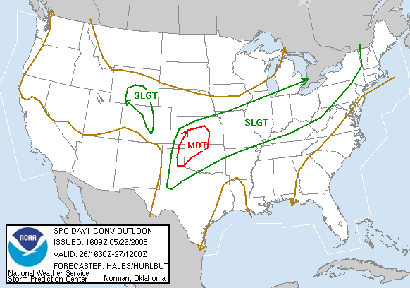
I ended up riding with Daniel Betten and a friend of his, and we left Norman just after noon. The main focus for the day would be an outflow boundary that arced northwestward from around Stillwater to Attica KS to near Jetmore, then curved back southwestward toward Liberal. A dryline from W KS into the W TX Panhandle would provide another focus for initiation, but the environmental shear was quite lacking for tornadoes, so we were depending on storms crossing the OFB for any decent potential. We headed towards the Northwest Passage off I-40, but turned north out of Watonga, as we felt getting north sooner was more important than getting west. We continued north to Alva, and eventually stopped in Medicine Lodge to take a closer look at things. At that point, a few cells were going up in W OK and the E TX Panhandle, but they looked multicellular and unimpressive. However, as it was now mid-afternoon and there was little sign of initiation on the OFB, we figured we should head west and follow these storms, hoping they'd hit the boundary before dark. So it was off through the Gypsum Hills west of Medicine Lodge on US-160, where roads and cell service are precious commodities.
Not long into our trip towards Coldwater, the western sky quickly filled with new updrafts, the focus for which I still cannot identify since the dryline was considerably farther west; LBL was reporting SSE winds with a Td of 60 F. When we reached US-183 at Coldwater, there was a cell immediately to our west, the base of which was nicely visible, along with chasers aplenty. Unfortunately, data service was still a no-go for me. So we started north towards Greensburg, where I knew from previous chases I'd have a signal; we had to get within a few miles of town to pick it up. Once there, we saw the predictable mess of small cells going up from near Ness City southward all the way into W OK. The most robust looking storm, and the only one tornado-warned at the time, was located near Shamrock, some 150 miles to our south and hopelessly far from the boundary. Despite the abundance of chasers on the Coldwater-Greensburg cell, we decided to begin heading southward in the hopes of intercepting a cell (or multicell cluster) moving NNE into Beaver County OK, which looked to be about the most isolated game in town at that point, and which could perhaps make it to the westward-creeping OFB by sunset.
After a quick re-fueling in Coldwater, we began to trek westward toward Protection and Sitka. I had picked up another quick radar update through wi-fi while stopped, and no more than three minutes later, noticed upon further expection that the Coldwater storm we were abandoning had much higher tops than only 10 minutes prior, as well as signs of low-level rotation. Stressed, we pulled off and made a quick decision to reverse course once again - if nothing else, we planned to sit in Coldwater on the wi-fi a bit longer and let the radar determine our final choice. But that wasn't necessary; as soon as I picked up the signal, the pink polygon (torando warning) reared its head over Kiowa County (along with a nice couplet on tilt 1), and it was off to the races - back north towards Greensburg!
Approaching the ravaged town once more from the south on US-183, we could see a messy lowering about 5-7 miles S of Greensburg, with the core sitting squarely over the main E-W highway through town - the very route we needed to use to get on the "right" side of the meso. For the next 20-30 minutes, we inched eastward towards Pratt, perpetually under a downpour but at least avoiding the baseball-size hail that was reported to have busted chaser windshields down the road. By the time we were approaching Pratt, tornado warnings for the storm had long-since been dropped, and visually everything was the definition of "mess." When we finally emerged from the core less than a mile from town, we could see the storm base was quite low and had some nice motion to it, but still decided it was time to call it a day and begin dropping south. What we had temporarily forgotten was the magic of late-spring boundaries! No sooner had we begun driving south through downtown Pratt to begin the drive home than I noticed an "interesting" lowering behind some buildings just to our SW. Less than a minute later, Daniel and I observed a brief but surprisingly vigorous torando about 2 miles to our SE. It could best be described as a 10- to 15-second touchdown of one of several vortices that appeared to be dancing around a fairly compact parent circulation. Given the time of day (around 7:30 PM by this time), extremely poor contrast and HP nature of the storm, and worst of all the brevity of what we saw, no pictures were obtained. It actually reminded me of the 2007-03-30 joke of a tornado I witnessed near Waco, but was probably even less photogenic - if that's possible!
Following this, we raced back north to the main intersection to get east and hopefully regain a visual, but that was not to be. We were stuck in a continuous stream of chasers, many with the driving skills of an ape; and to make matters worse, and heavy RFD precipitation had overtaken us once more. Several miles east of town, we obtained a dry view again, but the show was over. Several chasers who had been east of town during the tornado reported it to have been on the ground for as much as 2-3 minutes, so we may have missed the best of it, but no particularly compelling photos were ever posted on Stormtrack; whether you saw it for 2 minutes or 2 seconds, this was really a stats-only type of torando (though this year, I'll take it). After meandering east ahead of the meso for another half hour or so, it began getting dark, so we headed home, stopping in Wichita for dinner. We observed some of the most frequent lightning I've witnessed while chasing near and south of the OK-KS border on I-35 in association with a strong line of storms moving towards the Tulsa and Bartlesville areas, which was a nice way to end the day.