Despite marginal CAPE, a supercell produces an amazing wall cloud and possible tornado in southern Kansas.
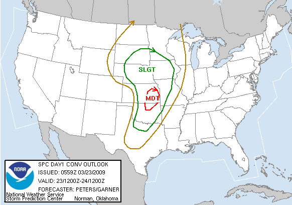
From a week out, the computer models had this setup looking almost like a classic Plains tornado outbreak. A deep trough was forecast to eject into the Plains in the March 22-23 timeframe, with the attendant surface low deepening into the 980-985 mb range over the central High Plains. To the south, strong winds at all levels (e.g.: 40-60 kt. at 850 mb, 60-80 kt. at 500 mb) would veer nicely with height over the warm sector. There were two main caveats: timing and moisture return. The diurnal timing of upper forcing did not turn out to be much of a limiting factor, at least over the Southern Plains. However, paltry moisture return owing to a strong surface high in the Northeast was likely responsible for keeping this potentially significant setup relatively tame.
By the day before the chase, lee cyclogenesis was already well underway over the High Plains, with strong SE surface winds over TX and OK. Unfortunately, the aforementioned lack of quality moisture over the Gulf meant that moist advection was unimpressive at best. On Monday morning, a 988 mb surface low was located near the northeast corner of CO, with the 500 mb low not too far behind to its W. A sharpening dryline extended S through western portions of KS/OK/TX, with mid- to upper-50s dew points generally the rule to its east. Morning cloudcover was somewhat concerning, but it gradually eroded from W to E around midday. Given the lackluster low-level moisture, we needed both solar heating of the boundary layer and mid-level cooling from the advancing trough to muster up decent CAPE values.
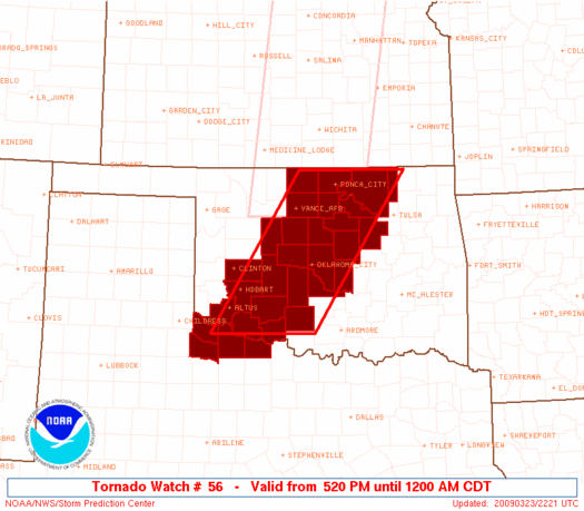
Not expecting initiation until mid-afternoon at the earliest, Brandon, Bryan and I planned to leave around 1:00pm for the Blackwell-Wellington area (i.e., I-35 near the OK/KS border). We were a bit surprised to see initiation occur along a good stretch of the dryline in KS and NW OK by 12:30pm, and took off as quickly as possible to the north. On the way, we monitored radar and saw that all the updrafts in OK were struggling against the cap, while one cell SW of Wichita was intensifying into a legitimate supercell. For a period, we became quite nervous as it acquired a nice hook on radar; fortunately for us, since we had absolutely no hope of catching up to it with the 40 kt. storm motions, it never managed to produce anything of substance before shooting off into much lower instability to the N.
When we reached the final I-35 exit in OK, we decided to head just a bit W for a closer view of the struggling cells that extended roughly from Harper County KS to Blaine County OK. We hung out at a gas station in Caldwell, KS, for upwards of half an hour before getting antsy and venturing even a bit further W to see the fairly unimpressive cores up close. Just as we did, one updraft to the south (near Enid) finally began to show signs of dominance, so we flew back E to prepare for an intercept. After about 20 minutes on poorly-maintained and unpaved backroads between Caldwell and Braman, we returned to I-35 at the exit we'd originally taken, about 3 mi. S of the KS border. By this time, our storm was clearly a supercell, with a nice inflow notch and velocity couplet on KICT.
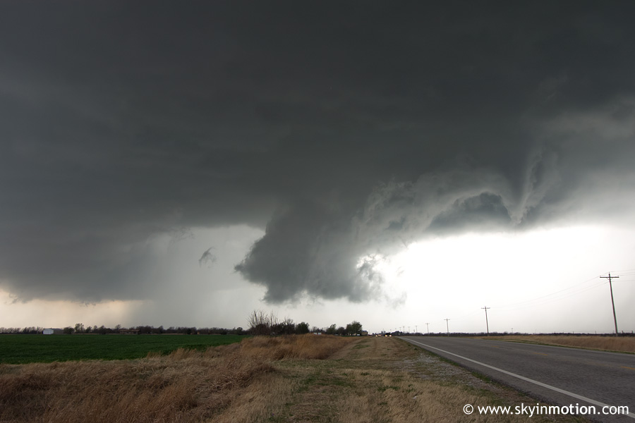
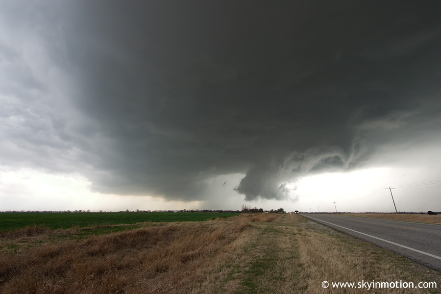
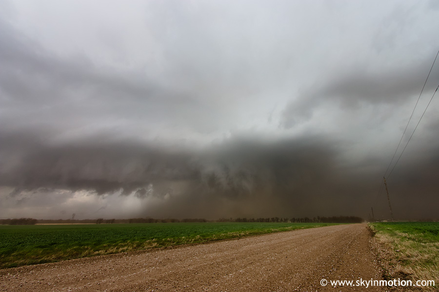
After only a few miles on the interstate, we took the first KS exit to US-166 eastbound towards Arkansas City. The core of the quickly-moving storm began to overtake us for a minute, dropping blinding rain and small hail until we could get back E of it. When we did, we looked back to see a significant lowering several miles to our SW, which was a pleasant surprise given how high-based and unimpressive the storm had looked just 15 minutes earlier. This lowering dissipated quickly, but a new wall cloud appeared just a hair S of the highway. Below is a view looking back W at this feature, which was only about a mile away.
The wall cloud raced off to the NE, so we (along with at least several dozen other chasers who had converged on the storm) continued E on US-166. By the time we reached the Sumner-Cowley county line, this wall cloud had become large, low-hanging, and had very impressive rotation and rising motion. We pulled off on a side road just N of the highway and prepared for what we thought would surely be a tornado, but within seconds, the raging RFD winds (at least 40-50 mph) kicked up a wall of dust all around us. This not only blocked our view, but blasted us and everything in our car with sand, as we had the doors open at the time.
Whether a tornado may have been lurking somewhere back in that mass of dirt is a matter of debate. A few chasers reported something on the ground at the time, but quite a few others who were watching the same thing (and apparently were not sandblasted like us) said they never saw any ground circulation, despite the incredible lowering. Needless to say, given the storm motions, we didn't have time to sit around and debate it at the time! We continued E with the hordes, but decided not to follow many of them up the first north option E of Arkansas City, instead choosing a diagonal route NE to Dexter. As luck would have it, that road turned out to be built into some type of valley with large hills to its NW, so we lost view of the storm base for at least 15 minutes. After arriving in Dexter, we continued N on KS-15 until it hit US-160 east of Winfield, and were finally back under the supercell. But now, it was rapidly moving out of the instability axis and into strong capping to the E. Given its visual appearance, it didn't lake long to decide there was no point in pursuing it any farther into an increasingly hilly and wooded area of southeast KS.
We dropped back down to Arkansas City via Winfield, with the plan of returning to I-35 so we could drop S towards several intensifying cells along the dryline in central and north-central OK (and, failing that, be on our way home). While navigating through Arkansas City, a storm approaching from the SSW briefly took on some impressive rotation on radar, so we wasted ~15 minutes waiting (under rain and hail in its core) to see how it evolved before continuing to the interstate. We hadn't gotten very far S on I-35 before the most impressive storm, which was moving from Kingfisher into Logan Co., OK, became tornado-warned, exhibiting a compact but impressive radar appearance. For a day on which instability was expected to be a major limiting factor, its updraft sure looked beautifully crisp from our position 50-70 mi. to its N, featuring a nice backsheared anvil. We planned to take the Indian Nation Turnpike E towards the Stillwater area for an intercept, but by the time we did, the storm had turned right (making it much more difficult for us to get to the updraft area without core punching) and weakened substantially, plus darkness had set in. We called off the chase near Glencoe and returned home, stopping for dinner in Stillwater.
Not our worst chase by any means, as the first supercell we intercepted from near Braman OK to Arkansas City KS was quite impressive, despite lacking a visible tornado (from our angle). Still, the ceiling of potential on this setup was quite high, and if we'd had widespread lower 60s surface Td's who knows what might have gone down. The 00z OUN sounding revealed >300 m2/s2 0-1 km SRH, >400 m2/s2 0-3 km SRH, and a surprisingly-decent 1800 J/kg SBCAPE. However, the 1238 m LCL (due to only mid 50s Td's at the surface) likely helps explain why no significant tornadoes were observed in the southern Plains even in the presence of such impressive parameters.