Just another early-season bust with dismal moisture return in 2009...
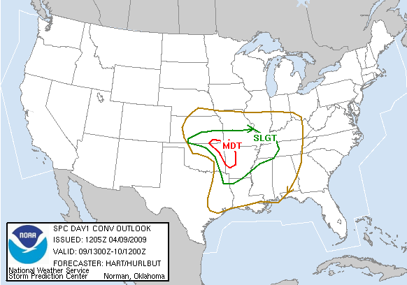
We watched what looked to be the first high-CAPE chase of 2009 fall apart before our eyes on the models for this one. As usual for 2009 thus far, moisture return looked worse with every run; the lower-mid 60s Td's progged from a couple days out would have yielded 2000-3500 J/kg SBCAPE, but that was not to be. To make matters worse, the 500 mb low was initially forecast to be centered over central KS at 0000 UTC on 10 April, but by the morning of the chase this had shifted south to the OK-KS border; this placed the target area of northeast OK and southeast KS in southerly to even southeasterly mid-level flow. Still, the SPC issued a MDT risk (including 15% hatched tornado probabilities) by the 1630 UTC convective outlook, given the favorable low-level wind profiles and potential for barely-sufficient moisture return.
Brandon, Bryan and I left Norman just before noon and headed up I-44 towards Tulsa. Once there, we cut north on US-75, then stopped in Bartlesville to grab lunch. After finishing, we hedged north to just across the OK-KS border at Caney. By this time, the dryline was advancing into Kay, Pawnee, and Lincoln County, with several small convective cells forming immediately to its east. We watched these storms attempt to get organized, but it just wasn't happening. Unsurprisingly, moisture return was underwhelming, with mid-upper 50s Td's the rule across all of eastern OK and southeast KS. At 2000 UTC, the RUC analyzed widespread >1500 J/kg SBCAPE over northeast OK and southeast KS, along with shear profiles sufficient for supercells. However, by the next hour, it indicated that SBCAPE had actually dropped to 1000-1500 J/kg over most of the region, and SBCIN <-25 J/kg was also widespread. Regardless of whether these values were to be taken literally, they were indicative of the state of the numerous dryline storms that had developed: pathetic, especially for a MDT risk day. Lackluster low-level moisture was hurting instability enough, but when all these storms went up at once, it really sealed our fate.
We sat just W of Bartlesville for awhile watching an absolutely abysmal storm become a high-based shower and nearly evaporate over us, then finally decided to head NW towards the most substantial cell at the time, near Sedan, KS. On our way, we had to navigate through a rather large wildfire in Osage County. By the time we got up to Sedan, the cell we were after was merely the tail end of a weak squall line that extended northward towards the Kansas Turnpike. We meandered E back to Caney, then called it a day (it was now about 5:30pm) and started heading home on the same route we'd taken (US-75 and I-44). The most exciting part of the day, by far, was encountering a few wildfires along I-44, and then checking out the more substantial Midwest City fire (which unfortunately burned dozens of homes) once we got back into town. While we had been dinking around with the worthless convection NE of the dryline, a much more interesting situation had unfolded behind it over central and western OK during the afternoon: widespread wind gusts of 60-80 mph were collocated with RH values <20%. This led to the worst outbreak of wildfires in recent memory, with infrared satellite showing over a dozen fires across OK and N TX during the evening hours.