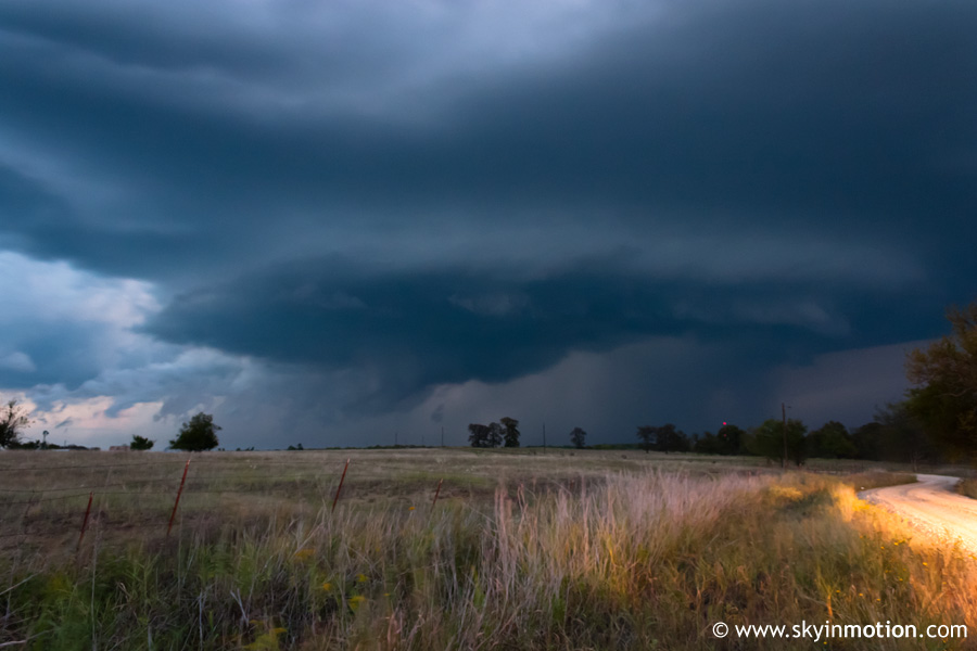
Cool structure for September with a supercell near the Red River in southeast Oklahoma.
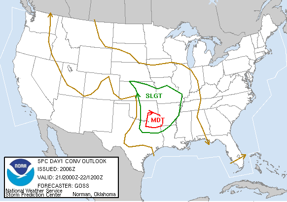
This week was another unusually active one for the Plains for September. From earlier in the week, it had appeared the primary threat with an approaching system was over the weekend in the Midwest and Mid-South, but by Thursday morning, things began to look more promising for the Plains. By Thursday afternoon, cyclogenesis was occurring on the High Plains of western Kansas with the a surface low under 990 mb. An attendant cold front and dryline were providing the focus for convection in the warm sector over KS and OK. Very strong winds veering with height provided a day with more than enough wind shear for severe storms; the limiting factor was expected to be instability, which turned out to be decent with temperatures warming into the 70s and 80s ahead of the front. Dew points of 65-68 deg. F existed ahead of the dryline, which moved only very slowly eastward during the course of the afternoon and evening, generally near a line from Lawton to El Reno to Ponca City. If only some of the spring chase days had been more like that.
With the surprisingly good setup in place and an upgrade to moderate risk with the early afternoon update, Brandon, Bryan and I decided there was no reason not to head out after classes, so we left for Ardmore a little after 3:00pm. When we arrived around 4:15 and stopped for wifi at a Microtel, we discovered that the same group of experienced chasers we'd followed on April 24 (El Reno tornadoes) were camped out there as well, so naturally, we stuck with them for the remainder of the day, poor souls. Hopefully we weren't too much of a burden or annoyance! We all agreed that if we ever become self-sufficient chasers (I know, it's a stretch), we'll owe it to the underclassmen to let them leech off of us too.
After about an hour in the parking lot watching a good Cu field but with little vertical development, things became more promising by the 6:00 hour. One tower to our southeast began to grow rapidly, so we jumped on it.
We headed down I-35, exited onto OK-32 eastbound to Madill just short of the Red River, and continued east into Johnston County. It seemed as though we managed to parallel the storm just to its south for most of this route. Unfortunately, the strong mid-level winds, while good for rotation, also had the consequence of rather fast storm motions. The intensifying storm dumped heavy rain on us a few times, and the storm's back edge appeared more defined with time, but nothing too serious was apparent for awhile. Eventually, we hit a dead-end on a dirt road near Milburn and ended up under heavy precipitation, so we got back on a main road and dropped south out of the rain. As soon as we got a clear view to the east, we saw surprisingly ominous structure with a possible wall cloud no more than 6-8 miles away.
We raced eastward for a couple miles into western Atoka County before stopping briefly in an open field to watch the wall cloud and break out the compulsory photo/video equipment. The lightning with this storm was mesmerizing, as CG strikes in and near the meso were nearly continuous, providing sporadic glimpses of the very intense rain and hail shaft in the now-low light. I was pretty stoked about the visual appeal of what we were seeing, but sadly, I was still using my 18-55mm kit lens (a.k.a., crap lens) at this time, and it lacked a marked manual focus ring. Since autofocus wasn't too helpful in the low light, I basically had to twist and hope for the best focus-wise; as you can see below, I was probably hoping for better. (This incident was one of the main reasons I upgraded to a new wide-angle lens for the 2007 chase season)
It was only a couple minutes before everyone wanted to get back in the cars and continue eastward to keep up with the escaping supercell. Up to this point, I had been very pleasantly surprised by the decent terrain for east of I-35, but as we pushed east into Bryan County, it rapidly deteriorated. By the time we turned northward onto a backroad east of Caddo, the landscape was more like Alabama than Oklahoma, with dense forest and painfully frequent hills. As we made our way up to OK-3 southeast of Atoka, we encountered some downed limbs.
While some of the other vehicles continued eastward trying to catch up with the still-impressive storm, we opted to head home since it was after dark and the terrain was only going to get worse. The drive back was a bit long and painful considering our straight-line distance from Norman was not all that much, but it wasn't without excitement thanks to a couple run-ins with terrible rural drivers.
This wasn't a bad chase day for late September by any stretch, but the camera issues I had were very agitating. This was definitely one of the more impressive-looking supercells I've seen, but I came back without any decent photographic evidence of it - hopefully that won't happen again.